
Na ‘Ohana Holo Moana: The Voyaging Families of the Vast Ocean, February 3-May 14, 1995
Introduction
Scholars believe that early voyages of settlement to Hawai'i, over 1600 years ago, came from the Marquesas Islands. The argument for a Marquesan origin of some of the early settlers is based on linguistic and biological evidence. Archaeologist Patrick Kirch writes, "Indeed, the close relationship between the Hawaiian and Marquesan languages as well as between the physical populations constitutes strong and mutually corroborative evidence that the early Hawaiians came from the Marquesas" (Feather Gods and Fishhooks 64).
Adzes, fishhooks, and pendants found at an early settlement site at Ka Lae on the Big Island of Hawai'i resemble those found in the Marquesa., Also, the Marquesas Islands are the best departure point for sailing to Hawai'i from the South Pacific because they are closer and farther east (upwind) than the Society Islands or the Cook Islands, two other possible places from which migrations came.
From 1990-1995, the Native Hawaiian Culture and Arts Program funded the construction of a double-hulled canoe named Hawai'iloa and a voyage to retrace the migration route from the Marquesas Islands to Hawai'i.
The building of Hawai'iloa (1990-1994) was designed to recover canoe-building arts and strengthen community in a joint effort to fashion a canoe entirely from native natural materials. The project faltered at first because of a startling discovery: there were no koa trees left in Hawai'i's forests large enough to build voyaging canoes. This alarming condition led to a new level of awareness about the interdependence of culture and environment and a commitment to malama Hawai' – take care of our island home. It also created another bridge across the Pacific – from Hawai'i to Alaska, whose native people offered the people of Hawai'i a gift of logs.
The 1995 voyage, called Na 'Ohana Holo Moana ("The Voyaging Familes of the Vast Ocean") carried on the work of the 1992 voyage – training new crew members and navigators, sharing voyaging traditions across the Pacific, and re-connecting Polynesian peoples through the heritage of the canoe. On the voyage from Tahiti and the Marquesas to Hawai'i, Hokule'a was joined by five canoes, Hawai'iloa and Makali'i from Hawai'i, the Maori canoe Te ‘Aurere, and two Cook Islands canoe, Takitumu and Te Au o Tonga.
Reports
- Preparing for Departure (February 3-11, 1995)
- Sailing to Tahiti (February 13-March 5)
- To Taputapuatea, Ra'iatea (Mar. 7-29)
- To Nukuhiva, Marquesas Islands (April 5-18)
- Sailing to Hawai'i (Apr. 20-May 2)
- In Hawai'i (May 3-14)
1. Preparing for Departure (Feb. 3-11, 1995)
February 3
Hokule'a and Hawaiiloa left Honolulu Harbor at 3:45 a.m., Febraury 1, 1995 and arrived in Hilo at 11 a.m. (Hawaiiloa) and 6 p.m. (Hokule'a) on February 2. Both canoes were towed all the way, along the north side of Moloka'i, Maui, and the Big Island, because of the light and variable winds. Seas were two feet and calm, with a huge swell rolling in from the NW and big surf breaking along the north coast of Moloka'i. Humpback whales were sighted off Moloka'i and the Big Island. The canoes are on schedule for departure sometime after the departure ceremony planned in Hilo on Feb. 6.
Hokule‘a
Hawai‘iloa
February 5
Makali'i, a third Hawaiian voyaging canoe has been launched at Kawaihae on the Big Island on Saturday, Feb. 4, 1995.
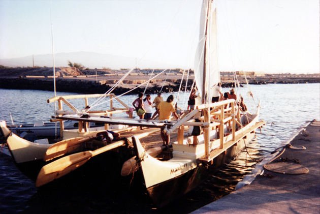
Makali‘i Launching at Kawaihae
The canoe, built by Na Kalaiwa'a (The canoe carvers), will be rigged on Feb. 5. Sea trials will follow. The double-hulled canoe is 54-feet long. Its hulls are fiberglass. The canoe is named after the star cluster known in the west as the Pleiades, whose appearance at the eastern horizon at sunset in the fall marked the beginning of the Makahiki, or harvest festival season in ancient Hawai'i.
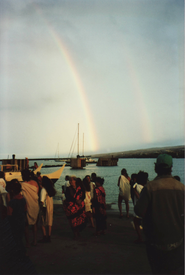
A double rainbow appeared at the launching of Makali‘i, an auspicious sign from the gods.
The builders include Clay Bertelmann, a veteran crew member of Hokule'a and a captain on the 1992 voyage to Tahiti; his older brother Shorty, a navigator of Hokule'a, who will navigate Makali'i; Tiger Espere, a veteran surfer and Hokule'a crew member; Billy Richards, a captain from Hokule'a's 1992 voyage and a crew member of the original 1976 voyage to Tahiti. When the canoe is deemed ready, these builders along with Maulili Dickson, Nailima Ahuna, and Chad Paishon, also veteran Hokule'a crew members, will sail the canoe to the South Pacific, hopefully in time for gathering of canoes at Ra'iatea on March 18.
Meanwhile, Hawai'iloa and Hokule'a are moored at Hilo Harbor. The latest word is that the two canoes will not leave for Huahine before Wednesday morning, Feb. 8.
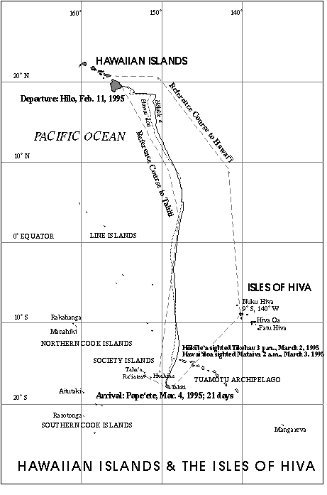
The sail strategy is to hold close to the Northeast tradewinds to gain easting, travel as quickly as possible across the doldrums (an area of light, fickle winds, dead calms, and heavy cloud cover from about 9 degrees N to 3 degrees S latitude, then head south against the Southeast tradewinds. The canoes will be navigated without instruments. Their target screen is a 400-mile wide band of islands from Manihi in the Tuamotu Archipelago (14.4 degrees S, 146 degrees W) and Maupiti in the Society Islands (16 .4 degrees S, 152.25 degrees W). They hope to arrive somewhere upwind, or east of their destination of Huahine. Once in their target screen, the navigators will look for changes in the swell patterns and the flight of land-based birds to find an island t hey can identify, which will give them their exact location. Then they will head for Huahine.
Daily reports will give the longitude and latitude of each canoe, based on readings from sealed, on-board satellite transponders. The reports will also give the navigators' estimates of their positions. Their estimated latitude will be based on their esti mates of distance travelled in a north-south direction and on their hand-measurements of stars crossing the meridian.
The navigators will give their east-west position in miles east or west of their reference course, a local zero degree longitude line that represents the most efficient route to the destination, given the average wind and current conditions between Hawai' i and Huahine, and the performance capabilities of the canoes. The canoes will not sail exactly on the reference course because wind direction and weather conditions will vary along the way. Cloud cover will prevent the navigators from using celestial bod ies, their most accurate guides to direction. The navigators will estimate the distance the canoes sail from the reference course, and record it in memory so that they will know how far east or west of their destination they are.
The navigators' estimated positions will differs from the longitude and latitude determined by the signals sent from the transponders on board the canoes to satellites orbitting overhead. Wayfinding does not produce or record exact physical data; it is a performance art that depends on and tests human intelligence, intuition, memory, and determination to reach one's destination; its theater is the open ocean.
February 7, 1995
Yesterday crew members from three Hawaiian voyaging canoes --Hokule'a, Hawai'iloa, and Makali'i-- participated in a departure ceremony for their upcoming voyage to Tahiti and the Marquesas. The ceremony, including traditional chanting and dancing, and sp eeches, was held on the grounds of the Naniloa Hotel on Hilo Bay, with the canoes moored offshore.
Hokule'a navigators are Keahi Oma and Ka'au McKenneyi, navigating their first long voyage.
Hokule‘a crew: sailmaster Nainoa Thompson and master Micronesian navigator Mau Piailug; Harry Ho, Mike Tongg, Ben Tamura, M.D.; Shantell Ching, Junior Coleman, Catherine Fuller, Sesario Sewralur (Mau's son); Tava Taupu, and Kamaki Worthington.
Hawai'iloa navigators are Bruce Blankenfeld and Chad Baybayan, both veterans of the 1992 voyage.
Hawai‘iloa crew: Snake Ah Hee, Kimo Lyman, Dennis Chun, Brad Cooper, Terry Hee, Eugene Kawelo, Reggie Keaunui, Palani Kelly, and Scott Sullivan.
Ho'okupu, or gifts, of banana, coconuts, and other plant foods for the voyage were presented.
Sailmaster Thompson said that the canoes will leave when the Northeast trade winds reestablish themselves, which could be as early as Wednesday.
February 9, 6 a.m.
Scheduled Friday departure confirmed by navigator Chad Baybayan. However, the date may change, pending weather.
February 10, 5:30 a.m.
Navigator Chad Baybayan said the departure time has been moved from Friday morning to Friday afternoon or Saturday morning.
A storm system is moving over the islands from the west, bringing rain on Friday morning. Once the center of the system moves past the islands, winds will shift to the NW, then N, good wind directions for the canoes to gain easting at the start of their j ourney to the South Pacific. As the system passes, the NE trades should fill back in.
February 11, 7 p.m.
Hawai'iloa and Hokule'a left Hilo Harbor around 5 p.m. this afternoon. Hawai'iloa was towed out of the harbor by Kama Hele, its escort boat, captained by Alex Jakubenko, who escorted Hokule'a on its 1980 and 1992 voyages to Tahiti; Hokule'a was towed by i ts escort Gershon II, under Steven Kornberg. Also accompanying the canoes is Rizaldar under Randy Wichman of Kaua'i. The third canoe, Makali'i, built in Waimea on the Big Island, is still undergoing sea trials.
Winds were northerly, 10-20 knots, gusting higher. A highwind warning was still in effect on Mauna Kea and Mauna Loa. The winds will decrease in strength and shift to the NE tonight. Seas 4-8 feet. The north wind, called Ho'olua, is a cold wind. The open deck and canvas shelters on the canoes will offer little warmth as temperatures drop on the open ocean tonight. The wind chill will compel the voyagers to bundle up.
2. Sailing to Tahiti (Feb. 13-18)
February 13, 11:30 a.m.
Navigators on the Hawai'iloa estimate the canoe to be at 18 degrees 40 minutes N, and 30 miles east of their reference course. This would place them about 80 miles SE of Cape Kumukahi on the Big Island. (The starting point of the canoes' reference course. )
The north wind has shifted to the south as a Kona storms approaches. Winds are southerly at 15 knots. Seas 8-12 feet.
The canoe is heading in a southeasterly direction at 3-4 knots. The weather has been good. Sailmaster Nainoa Thompson aboard Hokule'a expects the NE trades to return once the Kona storm moves east of the canoes.
Hawai'iloa and Hokule'a have been sailing together since leaving Hilo. Hawaii'iloa is in sight 2 miles west of Hokule'a. Sailmaster Chad Baybayan of the Hawai'iloa says that the new canoe is sailing well and taking on very little water in spite of its ope n hulls.
The first two nights were clear and cold due to the north winds, making navigation by the stars easy. The canoes are steering by a large N swell during the day. This swell is slowly diminishing.
Hawai'iloa has had better luck at fishing than Hokule'a. Fisherman Terry Hee caught an 80 pound ahi yesterday and a small mahimahi around lunch today.
Yesterday, crew member Richard Konn on board Hawai'iloa's escort boat Kama Hele was injured while cutting up a fish the escort boat had caught. While the injury was not serious, he was medivaced off the boat by the Coast Guard since the crew did not want to risk infection of the wound on the 4 week voyage to Tahiti.
The crews of the canoe will try to call two classrooms in Hawai'i a day to share their experiences with students. The first call today went to students of Ka Papa Honua o Keawanui, a Kamehameha Schools Alternative Education program at Moloka'i High School . The students had put on board Hokule'a a gourd containing three taro corms and three pia (arrowroot) tubers, protected by wet moss. Crew member Shantell Ching reported that the taro was sprouting and doing well. The students asked if they could send any thing to the crew once the crew reached Tahiti. Sailmaster Nainoa Thompson answered "Dried bananas. Can the students dry bananas from their farm to help provision Hawai'iloa on the way home?" Crew members want to try a traditional Polynesian diet on the w ay back to Hawai'i from Nukuhiva in the Marquesas Islands, explained Thompson. "How much?" the students asked. "Enough to feed a crew of eleven for about twenty days. I know that's asking a lot. Do what you can . . . "
February 14, 1:45 p.m.
Satellite Reading (8:09 a.m.): 18 degrees 44' N,152 degrees 16' W.
Navigators on board Hawai'iloa estimated the canoes to be at 18 degrees 30'N, 138 miles E of their reference course. Winds were from the S to SE at 10-12 miles per hour, and the canoes were sailing east at about 3-5 knots, waiting for the winds to shift s o they could take a more southerly tack. The canoe was about 170 miles E by S of Cape Kumukahi. The skies were sunny.
Hokule'a was out ahead of Hawai'iloa. How far back was Hawai'iloa? "Way back," said Nainoa Thompson on board Hokule'a. "We're doing 5 knots and they're doing 2." (Laughs, with the rest of the Hokule'a crew.) Scott Sullivan, radio man on board Hawai'iloa: "We'll see who gets to Tahtiti first!"
Earlier navigator Chad Baybayan explained: Hokule'a sails better than Hawai'iloa closed hauled to the wind [as the canoes were this morning, and as the/ canoes will be for most of the way to Tahiti]. Hokule'a points higher into the wind [without losing as much speed]. Hawai'iloa is faster sailing off the wind--it's lighter and faster off the wind. "We should do better on the way back from the Marquesas [to Hawai'i, when the canoes will be sailing with the wind coming from behind the canoe rather than in f ront of it.]
On the different feel of the two canoes: Chad says Hawai'iloa has a silkier feel, a smoother ride. It doesn't plow into the waves as Hokuel'a does, but glides over them, because of its rounder hulls (which is also why it doesn't sail as well into the wind , or close-hauled). The older Hokule'a also creaks more; the lashings are tighter on the newer Hawai'iloa. However, the crew has been hearing a strange noise coming from somewhere on the canoe. Chad wondered if a cat had snuck on board.
February 14, 4 a.m.
Satellite readings for 2/13, A.M.: 18 degrees 44' N, 153 39' W.
Satellite readings should be available daily after 9 a.m. HST, depending on avaiability of a person to fax them out. The designated person was not able to figure out how to fax the information from the computer yesterday morning.
Regarding slow progress for the first two days (only 80 miles): the canoes lost time while waiting for the Coast Guard to medivac an injured crew member from the escort boat Kama Hele (See 1/13 report.)
Progress should be better yesterday and today. At 3-4 knots (yesterday's estimated speed),the canoes will sail 75-100 miles per day. With stronger winds, the canoes will sail 5 or more knots (max speed: 10-12 knots), or about 120 or more miles per day (ma x about 200 miles per day). Two of the three escort boats have a max speed of 7-8 knots. The canoes at times will have to slow down (drop their sails) to allow the escort boats to catch up.
February 15, 7:45 p.m.
Hokule'a and Hawai'iloa were no longer in sight of each other this morning.
Satellite readings (around 8 a.m.):
Hokule'a: 18 degrees 17'N; 150 degrees 46' W (ARGOS)
Hawai'iloa: 18 degrees 32'N; 151 degrees 00'W (ARGOS)Hokule'a (1 p.m.): 18 degrees 4' N, 150 degrees 52 minutes W (GPS). The canoe has moved around 13 or 14 miles in 5 hours, average speed a little less than three knots.
Hawai'iloa (Navigators McKenney/Omai): 18 degrees 7' N; 197 miles E of reference course. Hawai'iloa is 20-30 miles NE of Hokule'a.
A rainy morning at sea. After three days of clear skies, high cirrus clouds hid the sky most of the night, only a few stars visible. The navigators steered by Hokupa'a (Polaris), almost stationary due north, and Hanaiakamalama (Southern Cross), which poin ts due south as it stands upright crossing the meridian at about 3:12 a.m. in the morning. The Kona storm which was over O'ahu on Monday and Tuesday moved east over the canoes. The rain was cold, but welcomed, allowing crew members take their first freshw ater bath since leaving Hilo.
The winds were light and variable, 5-10 knots out of the NW at the time of the morning radio call. The canoes were sailing south slowly, at 3-4 knots. The National Weather Service predicted the winds would gradually clock W, then S and remain S to Southwe sterly until at least till Sunday. Not good news. The canoes will be prevented from making much progress toward Tahiti. In strong trades, the canoes could reach 9 degrees north, the northern edge of the area of doldrums (Intertropical Convergence Zone, or ITCZ),to complete the first segment of their voyage to Tahiti in about a week. Now with the southerly winds, it will take them much longer. Having lost a day due to the rescue of the injured crew member on Sunday now has more significance.
Looking for wind: According to the National Weather Service, the NE trade winds are blowing between 10-15 degrees N at the longitude of the canoes (150 degrees W), a couple of hundred miles to the south. Another Kona storm is due in on Saturday, which may prevent the trades from reaching the canoe for an even longer time.
This is the first time the canoes have left for Tahiti so early in the year, during the northern hemisphere winter. Kona storms, typical at this time of the year, are disrupting the flow of the NE trade winds. (Earliest departure date: March 15, 1980, Nai noa's first voyage as navigator; Latest departure date: July 10, 1985, on the Voyage of Rediscovery).
Steering by the swells: After a large N swell diminished a couple of days ago, the swell pattern became confused, small swells from various directions due to the disruption of the trade wind pattern, the kona storm, the variable wind direction. The patter ns were gradually reforming this morning. Nainoa said he was reading three swells-- One from the north (created by the storm center north of Hawai'i, one from the NE (from the NE trades still blowing far to the NE of the canoe) and one from the SE (from t he SE trades, blowing below the equator.) According to Ka'au McKenney, the SE swell was the most distinct and he was using it to steer by.
Fishing: So far, small fish for Hokule'a: 2 aku, one eaten for breakfast; 2 mahimahi. Hawai'iloa: one 60 lb. ahi; 1 small mahi, 1 small aku.
Call placed to Kamehameha Schools: Monica Kaiwi's Pacific Literature Class--Student Nova asked about the awapuhi capsules placed on board to test the effectiveness of this traditional remedy for seasickness. Some crew members are taking the capsules. Acco rding to Nainoa, no one has gotten sea sick yet. The seas are fairly calm, so the remedy has not been truly tested.
Call placed to Wai'anae: Susan Lum's Marine Science Class: This class placed some live manauea (called ogo in Japanese), an edible seaweed, on board Hawai'iloa to see if would survive the 30-day trip. The class produces and markets manauea as part of an a quaculture project. Brad Cooper reported the seaweed was not doing too well. "Is it turning white?" asked Susan in kind of a panic. "Yes, it's turning white." "Are you changing the water in the bucket twice a day?" "Yes we're changing it twice a day." "Maybe you should change it more often." "Okay, we'll change it more often." "Is the water too warm? Are the tips of the seaweed out of the water? Is the bucket exposed to the sun and wind?" "The water is seawater. . . The tips are submerged . . . The bucket is in a partially shaded area." "Maybe there's too much in the bucket, can you take some out and eat it?" "Okay, we'll eat some." Brad, a teacher at Kamehameha Schools said the voyage is a dream come true for him. He has been teaching about voyaging and migration for years. Now he is actually participating in a voyage.
Susan asked to contact Hokule'a to find out if the crew had eaten the dried manauea her students had put on board. Mike Tongg confessed they hadn't. "You should eat it. You need to soak it in water first. I put some recipes on board." "Okay, we'll try it and report back next week."
Scott, on board Hawai'iloa: "We ate some of ours. We used to it make ahi poke [raw chunks of tuna mixed with seaweed, soy sauce, and other condiments that might be available]!"
February 16, 5:30 p.m.
Winds shifted to the east at midnight last night, an advantageous direction for the canoes, as it allowed them to head south (heading haka malanai, or S by E; with the current set factored in, they are sailing almost due south). Wind speed was 10-15 knots , and the canoes were going at 5-6 knots. A scattering of cumulus clouds suggested fair weather and the possibility that the trades were returning.
The canoes were sailing off the the wind, both crews were expecting Hawai'iloa to catch up with Hokule'a. They were on the lookout for each other, but hadn't caught sight of each other as of the morning report. Hawai'iloa was about 33 miles W of Hokule'a at about the same latitude.
Satellite readings (about 9 a.m.)
Hokule'a: 17 degrees 17' N; 150 degrees 59' W (ARGOS)
Hawai'iloa: 17 degrees 18'N; 151 degrees 32' W (ARGOS)Hokule'a (about 3 p.m.): 16 degrees 37 minutes N;150 degrees 55' W.(GPS)
Navigators' Estimate (Ka'au/Keahi on Hokule'a): 17 degrees 6' N; 187 miles E of the reference course.
The canoes have travelled about 100 miles due south over the last 24 hours. If they can reach 15 degrees N (about 100 miles to go) before Saturday, they can escape the southeasterly winds associated with a Kona storm that is expected to reach Hawai'i by S aturday, and find the NE trade winds they have been looking for since leaving Hilo.
Navigation: The SE swell remains the most distinct, the easiest to steer by. The night was cloudy, making navigation difficult, but the navigators were able to steer at times by Hokupa'a (North Star), keeping it directly astern as they headed south. The f ull moon was also an aid to navigation, rising five degrees north of E around sunset, and setting around 3 degrees north of W around sunrise. The bright planet Jupiter was also used as it rose ESE after midnight near Lehuakona (Antares) in the constellati on of Manaiakalani (Maui's Fishhook, or Scorpio).
Just as Hokule'a called Hilo High School (Milly Kaneshiro's class) at 9 a.m., Scott Sullivan reported catching a 10 pound mahimahi. Keahi joked,"Too small, that's the one we threw back!"
Brad Cooper reported to his 7th graders at Kamehameha Schools the only sea life so far has been a couple of booby birds, one which attempted to land on the mast, and something in the ocean that may have been a pilot whale.
February 17, 6:30 p.m.
Favorable easterly winds, at 15-18 knots, continued today for Hokule'a and Hawai'loa. The canoes were moving at about 5-6 knots. Navigators Baybayan and Blankenfeld on Hawai'iloa estimated their position 14 degrees 25' N, 78 miles east of their reference course. Their actual position at about 7 a.m. this morning was 15 degrees 33'N, 151 degress 8' W (ARGOS), about 60 miles farther north than their estimate.
Hokulea's was farther south and to the east at 15 degrees 15' N, and 150 degrees 46' W. The two canoes are sailing south on almost parallel courses, making about 120 miles a day.
Skies were patchy with clouds last night. The navigators used Hokupa'a (North Star), Hokule'a (Arcturus) rising ENE in the evening, and the red planet Mars, near Regulus, in Leo, rising ENE after sunset and setting WNW in the early morning. The SE swell c ontinued to dominate.
According to the National Weather Service, the canoes had sailed out of the area of southerly winds and should have easterly winds and fair sailing weather down through the area of doldrums and into the southern hemisphere. A high pressure ridge south of Hawaii has moved the trade winds farther south than usual.
Thunderstorms between 4-5 degrees N and 152-158 W should not affect the canoes as they cross the Intertropical Convergence Zone.
Hawaiiloa is sailing comfortably, taking on very little water in its open hulls. The crew reported pumping about 2 gallons per hour. The nights are getting warmer as the canoe moves away from the north winds and gets closer to the equator.
The two canoes will not try to find each other at this point, but to make as much distance as they can toward their southern destination in the favorable winds. When the winds lighten toward the equator, they may try to find each other and sail together a gain.
An historic event took place this morning: For the first time, a radio report was done in Hawaiian from a voyaging canoe. Crewmembers Reggie Keaunui and Dennis Chun of Hawai'iloa spoke with Kanoe Naone's 7-8th grade class at the Waiau Immersion School on O'ahu for about 30 minutes. They discussed, among other things, navigation, sailing conditions, sea life, and life on the canoe.
Navigator Blankenfeld reported that the crew was seeing very little life on the open ocean: an 'ake'ake (petrel) and lone 'a (boobies).
February 18, 4:45 p.m.
Hokule'a and Hawai'iloa continued to make good progress south in brisk tradewinds. The canoes are heading on a course SSE, with the current setting the canoes on a little more southerly course (S by E). At the time of the morning report, the canoes were s ailing about 5 knots. Two hours later they picked up speed, doing about 7 knots. At these speeds the canoes would make between 120-168 miles per day, and the canoes will reach the northern edge of the area of doldurms (about 9 degrees north) in about two days.
With sunny weather this morning, the crew of Hokule'a dried out their clothes and did their laundry. The crew cuaght an ono and a mahimahi today; yesterday, they caught two ono and two mahimahi.
After rain squalls in the evening, the sky cleared and the navigators had a full sky of stars to steer by. Hokule'a navigator Keahi Omai estimated the canoe to be at 13 degrees 46' north, and 75 miles east of their reference course. The actual position of the canoe (6:45 a.m.) was 13 degrees 15' N and 150 degrees 15' W, or about 96 miles east of their reference course.
The Hawai'iloa was about 50 miles NW of Hokule'a at 13 degrees 46' N and 150 degrees 47' W, still behind and farther to the west. Both canoes are losing the easting (the miles east) that they gained from their reference course at the start of the voyage a week ago. The canoes will have to hold onto some of that easting in order to arrive upwind of Tahiti.
Feb. 19, 3:40 p.m.
Hokule'a and Hawai'iloa continue their quick pace south, making about 150-170 miles SSE yesterday, parallel and to the east of to their reference course. Hokule'a is still making better progress close hauled to the wind; Hawai'iloa is behind, about 70 mil es to the NW. At 8 a.m. this morning:
Hokule'a: 10 degrees 48' N, 149 degrees, 02' W
Hawai'iloa: 11 degrees 41'N, 149 degrees, 39'W
News from Tahiti (from Vetea Hart of the Office Territorial D'Action Culturelle [OTAC]): Te Au o Tonga, the 70-foot Rarotongan voyaging canoe,was carried down to the harbor from the mountains three weeks ago,and will be launched on Saturday, Feb. 25. The canoe will be navigated by Tua Pittman and Pe'ia Tua'ati. The 70-foot Tahiti Nui, a Tahitian voyaging canoe (formerly called Hawaiki Nui), will be launched on Feb. 24, Friday. Both canoes intend to join Hokule'a and Hawai'iloa on the way back to Hawai'i.
Feb. 20, 7:10 p.m.
Hokule'a and Hawai'iloa made about 170-180 miles in the last 24 hours. Hawai'iloa has picked up some ground and is now within 60 miles of Hokule'a. The two canoes continue to hold their desired heading, sailing parallel to and 50-60 miles east of their SS E reference course. At 8 a.m. this morning the canoes were at:
Hokule'a: 8 degrees 30' N, 148 degrees, 02'W
Hawai'iloa: 9 degrees 33' N, 148 degrees 13'W
Hokule'a has sailed into the region betweeen 9 - 3 degrees N associated with light winds, doldrum conditions, heavy cloud cover, and thunderstorms. A weather map of the area the canoes have traveled into shows clear skies. The Kona storms passing over Haw ai'i have pushed the easterly trade winds farther south than normal, which could allow for quick passage through these latitudes just north of the equator.
Feb. 21, 7:10 p.m.
Latest satellite fixes from 6:30 p.m. last night.
Hokule'a 5 degrees 45' N, 147 degrees 26' W
Hawai'iloa: 6 degrees 9' N, 147 degrees 31 'W
Hawai'iloa has sailed to within about 35 miles, almost due north of Hokule'a. [Mahalo to Bernie Kilonsky of the UH Manoa Oceanography Dept. for e-mail providing fixes on the canoe twice a day. Data from ARGOS.]
Hawai'iloa has moved about twice as far as Hokule'a over a twelve hour period. It may be getting better winds; also it is lighter and sails better in light airs such as the canoes are now experiencing in the Intertropical Convergence Zone.
Report from morning of Feb. 21:
"Don't be surpised if I leave the radio--we're being blasted by a rain squall. Everyone's scrambling to trim the sails and and steer the canoe," said Scott Sullivan, our radio man on Hawai'iloa.
Each morning, he's the first person we contact at 7:30 in th e radio room of Peace-sat, a satellite communication station at UH Manoa which provides links to the Pacific Islands. When we contact Hokule'a, the crew is scrambling there, too, working the canoe in a rain squall. Nainoa's too busy to take a call from his dad.
This weather is typical of the Intertropical Convergence Zone, where the NE and SE tradewind belts meet. Lines of rain squalls with strong winds alternate with periods of light variable winds and calms. Hawai'iloa entered the area last night, about 50 miles behind Hokule'a. Hokule'a began to slow down over the last twenty-four hours--doing 80-90 miles (rather than 150-180 miles, as in the previous two days).
At 8-9 a.m., the canoes are doing 5 knots in the strong winds. An hour later the winds have diminished to around 5-8 knots, and the canoes are sailing 2 knots. At 8 a.m.this morning, Hawai'iloa navigator Bruce Blankenfeld estimates the canoe to be at 7 de grees 3' N and 44 miles east of the reference course. He is close--the canoe is at 7 degrees 13'N and about 80 miles east of the reference course (147 degrees 30' W)--ten miles of latitude and 34 miles of longitude off after about 900 miles of sailing.
The system of wayfinding by the stars and swells is definitely accurate enough to guide canoes over the long searoads of the Pacific. On the 1992 voyage back to Hawai'i, Bruce said he saw a path across the waves back home, even when the canoe was forced by the wind to sail in a direction he did not want to go in.
Bruce is navigating along with Chad Baybayan, another veteran of the 1992 voyage. Both are highly knowledgeable and experienced in their art. They take turns resting and sleep about 4 hours a day.
Bruce says the fishing has been perfect--they are catching one fish a day, yesterday a mahimahi, "just enough for a meal, no waste."
Last night the navigators steered by the rising Mars (ENE), and the stars of the constellation Leo, then later Hokule'a (Arcturus). Leo seems to pull Iwikuamo'o, or the North-South star line into the sky: Na Hiku (the seven stars of the Big Dipper--NE by N), Hokule'a (ENE), Hikianalia (Spica E by S), Me'e (Corvus ESE) and Hanaiakamalama (The Southern Cross SE by E)--a whole curve of navigation stars rising at different times along the eastern horizon. Bruce says the dominant SE swell has diminished, and t he largest swell is now coming from the E. Hawai'iloa has been riding well over the swells and taking on very little water.
Hawai'iloa has sailed a slightly more easterly heading than Hokule'a over the past 24 hours. The navigators try to stay east of their reference course so that they will arrive upwind of their destination, in this case Huahine or Tahiti. The two canoes are now at about the same longitude, with Hokule'a about fifty miles ahead.
Hokule'a: 6 degrees 26 minutes N; 147 degrees 24' W
Weather Analysis, based on data collected by the UH Meteorology department. On Feb. 21, the canoes should have winds from the east at 10-15 knots. Satellite photos show clouds over or near the canoes. [The rain squalls!] But they do not have the character istics of severe rainstorms [No great danger to the canoes]. Temp: 78-84 degrees, today and tomorrow. Forescast: more of the same for tomorrow. [Dan Schowerer, Meteorology Student at the UH].
News from Aotearoa: Hector Busby, canoe builder and leader of the Maori voyaging canoe revival, says his canoe Te ‘Aurere, will be shipped to Pape'ete, Tahiti, next Tuesday (Feb. 28, HST). The crew will fly to Tahiti in early March to join the canoe and sail with the fleet to Ra'iatea, Taha'a, Tahiti, Nukuhiva, and Hawai'i.
Feb. 23, 3:30 a.m.--12 days out
At 7 a.m., Feb. 22, Hawai'iloa was only 10.8 miles from Hokule'a, though still out of sight:
Hokule'a: 5 degrees 5 ' N, 147 degrees 17' W
Hawai'iloa: 5 degrees 14'N, 147 degrees 23 ' W
Hawai'iloa made about 140 miles to Hokulea's 90 in the previous 24 hours. Hawai'iloa's navigators estimated the canoe to be at 5 degrees 30'N, 44.5 miles east of the reference course. Hokule'a was in the middle of another rain squall, so communication wa s difficult, with heavy static on the radio. Hokule'a's navigators' estimate: 4 degrees, 48' N, Miles East: ? [Couldn't make out what Keahi was saying on radio.] Hawai'iloa was not in the rain squall yet; they have been experiencing better weather. Hokule 'a has gone to a 2 watch system (two teams alternating 6 hours on, 6 hours off), used when weather is bad so more crew members (6 rather than 4) are available for working the canoe.
Chad Baybayan (Hawai'iloa reported better than average conditions so far in the Intertropical Convergence Zone. Heavy cloud cover the night of Feb. 21, but enough patchy clearing to steer by celestial bodies. The planets were visible: Mars rising in the e vening ENE and setting in the early morning WNW; Jupiter rising ESE after midnight; Venus rising E by S in the early morning. Hokupa'a, the North Star, was also visible, about 4-5 degrees above the horizon and directly astern as the canoes headed south. T he moon was helpful. The departure was timed so the navigators could use the moon in the ITCZ, both for direction (rising and setting south of E last night) and to light up the swells at night.
The dominant swell was coming from slightly behind the canoe (from ENE), allowing the canoe to surf forward.
The latest readings from 6 p.m. last night:
Hokule'a: 4 degrees 13'N, 147 degrees 14' W
Hawai'iloa: 4 degrees 27'N, 147 degrees 30' W
Hokule'a made about 100 miles in the previous 24 hours; Hawai'iloa about 110 miles. Hawai'iloa is making less easting and is about 21 miles to the NW of Hokule'a. The canoes are less than 100 miles from the southern edge of the intertropical convergence z one (around 3 degrees N). This trip through the zone has been remarkably fast; navigation conditions, particularly for Hawai'iloa, remarkably good. Winds variable, but mainly easterly, up to 10-20 knots. Chad remembers, however, that in 1992 on the voyage south, southerly winds at the southern end of the ITCZ forced the canoes to tack east.
Weather Analysis for Feb. 22 [Dan Showerer]: Good sailing with east winds at 15-20 knots. The winds may shift more southeasterly as the canoes move toward the Equator. This could impede their progress. Rain could occur at any time. [Satellite photos show a long band of clouds running along the equator. Easterly to southeasterly winds are normal in the SE trade wind belt south of the equator.]
Hawai'iloa reported to the Wai'anae students that the manauea (seaweed) looks dead. Scott thinks the problem was not enough aeration in the bucket. They may leave the contents of the bucket in the doldrums.
No fish yesterday. Scott speculated that the canoes were moving too slowly (1-3 knots in 5-8 knot easterly winds at the time) to catch fish by trolling. Best fishing (from experience on previous voyages) seems to be when the canoe is moving at 6-7 knots. Dinner: clam chowder and rice.
Kimo Lyman, watch captain on Hawai'iloa, requested that we buy packaged saimin that is cooked in a pot, rather than "Cup of Noodle" saimin, which comes in styrofoam cups for individual servings: "We are saving all our garbage until the canoe reaches land because we don't want to dump anything in the ocean. The empty styrofoam cups are taking up too much space in the garbage bag on the canoe."
Feb. 24, 4:45 a.m.--13th day at sea
Both canoes reported they were out of the area of doldrums yesterday morning. The skies were blue, with fair weather cumulus clouds overhead. Winds were easterly at 15 knots, and the canoes were sailing at 4-5 knots. This was the quickest sail through the area of doldrums for Hokule'a, which is on its fifth voyage south.
At 7:30 p.m. Feb. 23, they were at:
Hokule'a: 1 degree 57' N, 147 degrees 52'W
Hawai'iloa: 2 degrees 19' N, 148 degrees 5'W
Both canoes have crossed the reference course and are now west of it. Ka'au on Hokule'a estimated 7 miles W yesterday morning. As of last evening, Hokule'a was 10 miles west of the reference course. Hawai'iloa was 20 miles west. They were about 25 miles a part. Both canoes sailed about 120 miles yesterday.
Weather analysis: Yesterday, winds were from the east from 10-20 knots. Tempatures in the 80's and will steadily increase as the canoes get closer to the equator. On the weather map, rain clouds moved a couple of degrees north of the canoes as the day pro gressed, so they had good weather. Forecast: Rain at any time due to the location near the equator. Winds will be 10-15 knots out of the east south east. [Dan Schowerer]
With winds out of the ESE, the canoes should be able to hold a course due south. However, their course on the satellite track shows that they are heading S by W. This track would take them to the west of their target of Tahiti/Huahine.
The crews are catching fish again. One aku on Hawai'iloa; one aku and one ono on Hokule'a. The Hokule'a count is now 23 fish, about two per day on average, since leaving Hilo.
Hokule'a crew member Cathy Fuller reported that the six kalo huli (taro cuttings used for planting) and 4 pia (arrowroot) tubers gathered and packeted by the students of Ka Papa Honua o Keawanui (Kamehameha Schools Alternative Education Program at Moloka' i High School) are still alive. Kalo was the main staple in traditional times for Hawaiians. The report on the Hokule'a Plant Project explains how the project was put together:
Masashi "Cowboy" Otsuka, kupuna on Moloka'i and well known mahi'ai o kalo (taro farmer) suggested sending three varieties of kalo: 'api'i, found abundantly in Waipi'o Valley on the Big Island; hearty under different conditions; piali'i, because it produce s much more poi than most varieties; and mana lauloa, found abundantly in the drier areas of Hawai'i (Kona, Keaukaha, etc.), very hearty.
Students prepared the gourd to hold the kalo cuttings: The gourd (14" x 20") was sanded and rubbed with kukui nut oil to make the surface resistant to saltwater and rainwater. Penny Martin and Mel Paoa, two Moloka'i residents who have sailed on the canoes , suggested a net be made from sennit to carry the container, secure the top; and so the gourd could be hung, thus avoiding contact with water running over the deck or in the hulls due to wave action. Mike Wada, program counselor, made the net. Students g athered moss and coconut husk for packing. Kupuna Otsuka instructed students to squeeze the moss and husk to remove excess water. The coconut husk was placed at the bottom of the gourd; then some moss; then the kalo cuttings; then more moss and coconut hu sk.
Students of Keawanui: Jamie Aki, Anthony Burrows, Michelle Horcajo, Steven Kaholoa'a, Shannon Puaoi, Edmund Lima III, Blaine Isabel, Anthony Naki, Mason Nakihei, Sean Young, Amie Lalim, Georgette Stevens, Daniel Gonzalez, Obrien Muller. The Staff: Rose Mo reno, Site Manager; Mike Wada, Counseling Specialist; Nick Akana, Teacher/Counselor; G. Keoki Schnackenberg, Teacher/Counselor; Paula Friel, Teacher; Carmen Augustiro, Clerk; Doug Kingsley, Maintenance.
Medical report from Dr. Ben Tamura: Amazed at how difficult the voyage is on the body. Always cold, wet, and hungry. Original settlers of Hawai'i must have been very fit to make their voyages. The crew of Hokule'a is in good condition, mainly because they prepared well and were in good health when they left Hawai'i. Canoe can be a healthy environment if hygiene is maintained and the men on board "aim properly." The awapuhi (ginger root) remedy for seasickness seems to be working well. Dr. Tamura is taking the capsules of awapuhi himself, and "This is the first time I haven't gotten seasick". Four other crew members are participating in the experiment: 2 taking awapuhi and 2 taking placebos of cornmeal. The experiment was designed Nova Suenaga, senior at Kamehameha Schools.
Feb. 25, 3:15 a.m.--14th day at sea
Hokule'a was 3 miles south of the equator at 7 p.m. last night; Hawai'iloa was still ten miles north and about 35 miles to the west of Hokule'a.
Hokule'a: 00 degrees 03' S, 148 degrees 04' W
Hawai'iloa: 00 degrees 10' N, 148 degrees 39' W
Hokule'a, on a course due south, is again east of its reference course; Hawai'iloa has also taken on a more southerly direction and is tracking back towards the reference course. The canoes are on parallel courses and made about 130-140 miles over the las t twenty-four hours.
Nainoa Thompson, sailmaster on Hokule'a, reported that the canoe has picked up speed in 15-20 knot easterly winds and are doing about 7 knots. At this pace the canoes could be in the latitude of the Society islands--17 degrees S--in about 6.5 days. The tw o canoes are over half way to their target of Huahine/Tahiti about 1000 miles to the south.
A.M. report: Scott, radio man on Hawai'iloa, said that so far, this trip has been the best sailing he's ever done on the canoes. The wind is brisk, the seas relatively flat, with a small SE swell and a smaller easterly swell. The crew is catching fish aga in--yesterday an aku and a spearfish.
Kimo Lyman, watch captain, aboard Hawai'iloa reported that the crew had not touched the helm in the last twenty-four hours. They steered the canoe by adjusting the weight on board and trimming the sails. He noted that the difference between Hawai'iloa and Hokule'a was that Hawai'iloa tended to run down wind, while Hokule'a tended to turn into the wind.
Lyman reported that last night, a pod of nai'a (dolphins) visited the canoe for about forty minutes. The playful mammals leaped and splashed around the canoe, darting past and circling around beneath a full sky of stars. They left phosphorescent trails in the water, appearing like small torpedoes or ghostly dancers as they streaked past the canoe. The crew watched in awe.
After midnight, the waning quarter moon rose south of E, big and orange, like the grin of a Cheshire cat. Scott said it seemed to be symbolic of the good fortune the canoes have experienced so far on the voyage. In the clear night sky, the 10 p.m.-2 a.m. watch steered by Na Hiku ("The Seven [Stars]" or the Big Dipper) rising NE by E; Lehuakona ("Red flower of the southern sky" or Antares), the bright red star of Manaiakalani (Maui's Fishhook, or Scorpio) rising ESE; and Hanaiakamalama ("Cared for by the m oon," or the Southern Cross; the cut of the quarter moon, or the line between light and shadow, is oriented north-south, with the southern end pointing toward the Southern Cross, which points due south).
Hokupa'a, the North Star, a couple of degrees above the horizon now, was no longer visible through the atmosphere of the earth. This star drops toward the horizon as the canoes sail south, one degree down for each degree of latitude south. At the equator it is at the horizon. Catherine Fuller of Hokule'a predicted the canoes would be crossing the equator today (Feb. 24).
In response to a question by 4th graders in Tanya Wills class at Kilohana School on Moloka'i, Kimo Lyman said the crew has not had to ration water so far; in fact, they had gathered 20 gallons of rainwater and taken freshwater baths in the rain squalls in the Intertropical Convergence Zone.
Weather Analysis: The canoes are between a low trough and a high ridge. The back edge of the trough runs through (140W, 10N) and (145 W, 0). The upper level winds show subsidence aloft. This means good weather for the next 24 hours. The satellilte picture shows light stratus clouds moving east to west with the winds. These clouds should not produce any serious rainstorms. The surface level maps show east winds at 10-20 knots. This is atypical of equatorial weather. The forescast looks like clearing and go od winds out of the east for the next couple of degrees south (120 miles). A high pressure cell over Tahiti and tradewinds from the ESE at 10 knots are waiting fo the canoes in the southern hemisphere [Bernie Kilonsky].
Feb. 27, 1995--16th day of the voyage, 5 a.m.
The canoes continue their southerly course, making about 110-120 miles a day. At 3 p.m (HST) , Feb. 26:
Hokule'a: 4 degrees 13'S; 148 degrees 23' W
Hawai'iloa: 3 degrees 57'S; 148 degrees 44'W
Hokule'a is about 16 miles south and 21 miles east of Hawai'iloa, about 10 miles E; Hawai'iloa is 10 miles W of the reference course. The canoes are about 1500 miles from Hawai'i. Pape'ete, Tahiti, the primary destination, lies 800 miles to the south.
Report from Feb. 25, Saturday a.m. Nights have been remarkably clear. The navigators are able to use all the stars and planets in their navigation. Wind is coming from E by S, swells from the E. Heading: Haka Malanai (S by E) to gain easting; later the pl an is to head Hema (S).
No dolphin visitations last night: Birds such as the 'a (booby) and 'ewa'ewa (sooty tern) attempt to land on the rigging. The crew chases the birds off to prevent droppings on the canoe.
News from the Big Island: The canoe E'ala will arrive on a barge at Kawaihae on Monday to begin a Polynesian Voyaging Society Exploration Learning Program on the Kona Coast. Students from Hilo, Konawaena, Ka'u, Hale o Ho'oponopono, and Na Pua Noeau will p articipate. Angel Pilago is the PVS coordinator in Kona; Kahualaulani Mick will serve as head trainer.
Makali'i, the 52 foot voyaging canoe built in Waimea, left Mahukona 3 a.m. Sunday Morning for Hilo, from where the canoe will depart for Tahiti. Shorty Bertelmann is the navigator. Shorty Bertelmann is the navigator; Clay Bertelmann, the captain.
Makali‘i Crew: Tiger Espere; Billy Richards; Maulili Dixon; Chad Paishon; Mike Manu; Darrell Lapulapu; John Shore; Ernest Reyes.
Feb. 28--17th day of the voyage, 6 a.m.
Latest ARGOS fixes from Bernie Kilonsky at UH Manoa (3 a.m. on Feb. 28):
Hokule'a: 8 degrees S, 148 14'W
Hawai'loa: 7 degrees 24'S, 148 degrees 14.6'
Hokule'a is 75 miles due south of Hawai'iloa. It has sailed about 45 miles since the last fix at 6 p.m. last night. Average speed: 5 knots.
At 6 p.m, Feb. 27, the canoes were at:
Hokule'a: 7 degrees 15' S, 147 degrees, 51 minutes W
Hawai'iloa: 6 degrees 40'S, 148 degrees 26 minutes W
Holding courses of Haka Malanai (S by E), they are both east of the reference course and in good position for the final run to Tahiti. Hokule'a was averaging 6.6 knots over the 24 periods from 6 p.m. Feb. 26 to 6 p.m. Feb. 27; at 6 p.m., Feb. 27, it was 4 50 miles due north of the giant atoll of Rangiroa in the Tuamotu archipelago. At the current speed, the canoe could make landfall there in 3-4 days (Mar. 2 or 3). Tahiti lies another 150-200 miles beyond the Tuamotus. At 6 p.m., Feb. 27, Hawai'iloa was ap prox. 50 miles NW of Hokule'a averaging 6 knots.
The success of this voyage depends not on staying on the reference course, but on making landfall somewhere in a 400-mile wide target screen which stretches from Manihi atoll in the Tuamotus (14 degrees 25' S, 145 degrees 57' W) to Maupiti (17 degrees 27' S, 152 degrees 15'W), one of the westernmost islands in Tahiti Nui (Society Islands). Once an island is identified, the navigators will set a course for Pape'ete, Tahiti. They have memorized the positions of dozens of islands in the Tuamotus and Tahitit Nui and the directions in which their destination of Tahiti lies from these islands.
On the morning of February 27, Kimo Lyman on board Hawai'iloa reported east winds of 10-15 knots, a small E swell, and an even smaller SE swell. The navigators' estimated position was 4 degrees S, 59 miles east of the reference course. At were actually ab out 100 miles farther south, and about 10 miles east of their reference course.
Weather Analysis (Dan Schowerer for 2/26): Surface charts show east winds at 10-15 knots. Upper level winds are west at 10-20 knots. The canoes are still in an area of subsidence, which should keep skies fair and for the most part clear. A trough located at (155W, 140W, 15S, 30S) is proudcing rain south of the canoes. The satellite photo shows low clouds moving with the wind to the east, with clouds at 160W, 150 W, between 6S and 10S. The green and blue on the IR image indicates rain in the area. As the c anoes sail toward the 5 degree line, they will get closer to the rain. The winds should continue east at 10-15 knots.
March 1--18th day of the voyage, 6 a.m.
Latest ARGOS fixes:
Hokule'a (12 noon, Feb. 28): 9 degrees S, 148 degrees 12'W
Hawai'iloa (3 a.m. Feb. 28): 7 degrees 24' S, 148 degrees 14'W
The canoes are travelling south at about 1 degrees (60 miles) every 12 hours. By 12 noon today, Hokule'a should be around 11 degrees S, Hawai'iloa about 10 degrees South. The Marquesas Islands lie about 350 miles to the east.
Report for Feb. 28, a.m.: Scott reported that the crew had just pulled in a 130 lb. marlin; then he reported it was a 200 lb. marlin. Dennis: "The fish seem to grow in size out there after they're caught!" Scott: "No, really. It's twice as big as Bruce (Blankenfeld, one of the navigator), so it's at least 200 pounds!"
The marlin was cut in half and half of it was floated back to the escort boat Kamahele. Hawai'iloa's fish count: 15 total (4 mahimahi, 4 aku, 4 spearfish, 2, 1 marlin). Hokule'a's fish count: 28 (11 mahimahi, 9 ono, 7 aku, 1 120 lb. ahi). Scott: "We are c atching one fish a day and pulling in the lines." Dennis: "They're catching more on Hokule'a." Scott: "They must have bigger eaters on their canoe."
Request from Tom Chun's Kamehameha Schools Science Class: Save rainwater for chemical analysis. (Mike Tongg: "We have some empty mayonnaise jars; we'll wash them out and bring back some rainwater." Tom: "Okay, if we find mayonnaise oil in the analysis, we 'll know where it came from."
How do you predict weather at sea? Nainoa Thompson explains you need to scan the horizon as far as you can see. You look at the wind speed and direction, the types of clouds and their shapes, and the size and direction of the swells.
When will the canoes start looking for signs of land, such as birds? The crew was looking for birds today because they estimated they were near the latitude of Caroline Island (10 degrees S, 150 degrees 15' W), and the island was about 120 miles to the we st.
Weather Analysis: The satellite image showed clearing in the area of the canoe. [The canoe reported a bright, sunny day; nighttime clouds melted in the morning.] The surface chart showed east winds at 10 knots. Forecast: Look for winds to continue out of the east, and light rain from scattered clouds. (DS, 2/28)
March 2--19th day of the voyage, 4:30 a.m. HST
Yesterday morning at 8 a.m. the canoes were at:
Hokule'a: 11 degrees 16' S; 147 degrees 54' W
Hawai'iloa: 10 degrees 36' S; 148 degrees 13'W
The voyaging canoe Makali'i left Hilo on Feb. 28. On the morning of Mar. 1, it was SE of Hilo at 19 degrees 8'N, 154 degrees 06'W.
Last night at 7 p.m., Hokule'a was at 12 degrees, 27' N, 147 degrees 39' W. It continued to head south at a little over 1 degree, or 60 miles per 12 hours. This morning the canoe would be about 13 degrees 30' N, about 150 miles north of and a day's sail f rom the giant atoll of Rangiroa in the Tuamotus. They could sight land tomorrow morning. Atolls, on which the highest feature is a palm tree, can be sighted from 7-10 miles out from the mast of a canoe. Formula for line of sight: The square root of the he ight of the observer (Feet above sea level) + the square root of the height of the object observed (Feet above sea level) x 1.3 nautical miles or 1.5 statute miles = miles away an object can be seen.
Mar. 1, a.m. report
The seas were getting lumpier (6-8 ft.) and the wind picked up at bit to 12-18 knots, still easterly. The wind started to get strong around sunset and moderated at about 10 p.m. The canoes are sailing at 5-6 knots. Hawai'iloa is pumpi ng about 3-5 gallons of water out every 20-30 minutes from its open hulls--not a major problem, but a lot of work for the crew.
Fishing continues to be great: Hawai'iloa caught 3 small ahi just before breakfast; Hokule'a reported hooking 2 ono (20 and 30 pounds) and 1 ahi.
Last night Chad Baybayan of Hawai'iloa said he and Bruce used Duhbe in the Big Dipper, and Holopuni (Kochab) and Pherkad in the Little Dipper as these stars crossed the meridian, to determine latitude and correct for any error in dead reckoning. He estima ted Hawai'iloa was at 10 degrees S and 84 miles E of the reference course.
Joe of Peacesat: "Once you make landfall, will you recognize the island you found?" Nainoa: "I would recognize any of the Society Islands and the four western islands of the Tuamotus: Matahiva, Tikehau, Rangiroa, and Arutua. If the canoe arrived at one of the islands farther east, I wouldn't know which one since I've never been to those islands."
"Have you sighted any birds yet?" Chad: "Not any land based birds. We sighted some tropic birds (koa'e) yesterday. We'll start looking for land birds in a day or two." [The canoes could make landfall Friday, Mar. 3.]
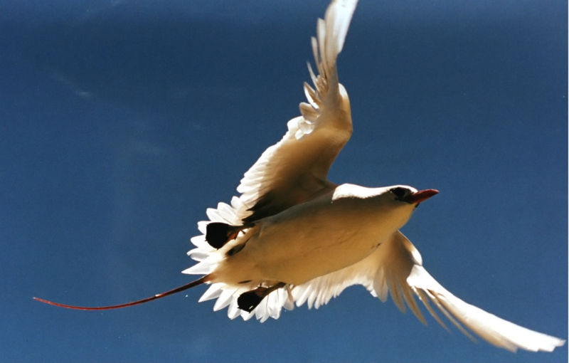
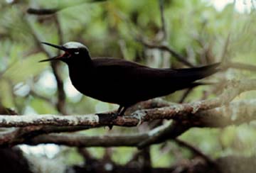
Koa‘e ‘ula
The koa'e, or tropic bird, is noted for its long red or white tail feathers which appear like streamers behind the bird as it flies. The koa'e nests in the cliffs, such as those found in the Marquesas Islands and Hawai'i. It is capable of flying "for long periods without rest, alternating soaring glides with fluttering wingstrokes. They seldom rest on the water, but they can float buoyantly with their streamers cocked." Since they do not necessarily return to land each day, their presence is not an indica tion that land is near; and their flight at sunrise and sunset does not indicate the direction of land.
"Christopher Columbus was ignorant of the biology of these birds. On September 17, 1492, at 36 degrees west in the mid Atlantic, he wrote in his diary that he saw a tropicbird and therefore must be near land because the species 'is not accustomed to sleep on the sea.' Columbus was nowhere near land." (Seabirds of Hawaii: Natural History and Conservation by Craig S. Harrison, "Tropicbirds," pp. 166-174.)
March 3--20th day of the voyage, 3:45 a.m. HST
At 7:30 p.m. last night the canoes were at:
Hokule'a: 15 degrees S, 148 degrees 17'W
Hawai'iloa: 14 degrees 5'S, 148 degrees 39'W
Hokule'a is a couple miles west of the atoll of Tikehau. The crew should have sighted land yesterday afternoon. The canoe appears to be rounding the atoll and heading for Pape'ete, about 160 miles SSW. It should arrive there early Friday afternoon. This h as been the fastest passage for Hokule'a in its five voyages south; in the past the voyage has taken up to 32 days.
Hawai'iloa is about 60 miles N by W of Hokule'a, on a course toward Mataiva, the westernmost of the Tuamotus. They may sight the island this morning at dawn.
The day before yesterday, the crews began seeing land-based birds that fish at sea: noio (noddy terns) and manu o Ku (fairy terns), though not in piles fishing, but lone birds. Hawai'iloa reported a noio followed the canoe for 3-4 hours and landed on the canoe.
noio (noddy terns)
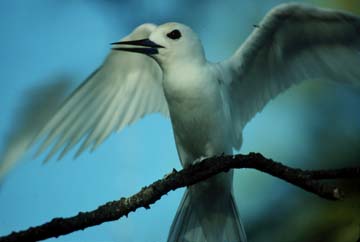
manu o Ku (fairy terns)
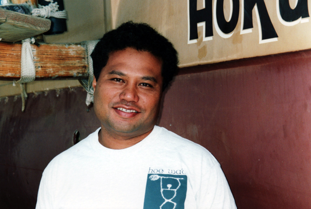
Interview with Sesario Sewralur, son of Mau Piailug, the 14th of 16th children: Both are crewmembers on Hokule'a. According to Sesario, Mau is the youngest of the navigators on Satawal, Micronesia. Mau is over 70 years old. Sesario is studying long distance, non-instrument navigation on this voyage and hopes to carry on his father's tradition.
Makali'i Report: At 7:23 a.m. March 2, Makali'i was at 18 degrees 2' N, 153 degrees 04'W, heading SE from Hilo at about 3.5 knots, about 150 miles out.
March 5--22th day of the voyage, 7:20 HST
Tahiti
Hokule'a and Hawai'iloa were towed into Pape'ete Harbor yesterday morning, March 4, at 9 a.m. for welcoming ceremonies on shore. The two canoes rendezvoused off of Pape'ete in the early morning before dawn; at dawn, they saw each other for the first time in over two weeks.
Hokule'a made landfall on March 2, sighting the island of Tikehau at 3 p.m. After identifying the island and determining their position, the navigators Keahi Omai and Ka'au McKenney, who had both completed their first long voyages, turned over navigation to their apprentices Junior Coleman and Sesario Sewralur, who then guided the canoe to Pape'ete.
Hawai'iloa made landfall in the South Pacific for the first time. Navigators Bruce Blankenfeld and Chad Baybayan, after picking up land-based fishing birds (Noio, or Noddy Terns, and Manu o Ku or Fairy Terns) on the afternoon of March 2, followed the bird s. At 2 a.m. in the morning, the crew sighted lights and from the isolation of the lights, guessed the island to be Mataiva, 30 miles west of Tikehau.
In the light of dawn, the crew sighted and identified Mataiva, and continued on to Pape'ete. As the canoes were towed into Pape'ete Harbor, Hawai'iloa crew member Brad Cooper talked with his Kamehameha Schools 7th grade students over the radio.
What did he miss most? Things that were refrigerated. He looked forward to eating ice cream. What was his greatest fear during the voyage? Falling overboard and being lost as sea. Were they ever in danger of running out of food? No, because they caught so much fish [and because the voyage was so fast]. The crew ate only one-third of their food supply. What did he do on watch? Steer the course set by the navigators. Trim the sails. Pump the open hulls every half hour. Check the rigging for loose or frayed lines. Boil water to make cocoa or coffee for the next watch. Did they encounter any storms? Mainly squalls in the area of the doldrums. Did the canoe hold up well? One cracked decking plank. It needs more caulking. Otherwise, it did remarkably well. What was the first thing he planned to do on shore? Laundry. Would he go again on a long voyage? Given the opportunity, Yes!
The crews will spend the next week on repairs and maintenance and working with the Tahitians, Cook Islanders, and Maoris, as they prepare their canoes for the upcoming voyages. The canoes will gather at Huahine on March 16 before crossing the channel to R a'iatea on March 17 or 18 for ceremonies at Taputapuatea.
3. To Taputapuatea, Ra'iatea (Mar. 7-29)
March 7, 6 a.m. HST
Voyaging canoe Makali'i was last reported at 14 degrees, 45' N, 149 degrees, 23' W. at 7 p.m. on March 5. Makali'i was then 443 miles from Hilo, and 1936 miles from Tahiti, travelling at 3 knots in a southerly direction. The canoe is being escorted by "Good Wind" captained by Terry Causey.
The crew hopes to reach Ra'iatea by March 18 to particpate in the rededication of the marae of Taputapuatea. It needs to travel an average of about 140 miles a day (about 6 knots) to make it there on time. The canoe left Hilo on February 28.
March 11, 3:45 a.m. HST
Change in Sail Schedule for Voyage Back to Hawai'i:
March 21: Canoes will go directly from Taha'a to Tautira, without stopping in Pape'ete. (Escort boats may refuel at Pape'ete.)
March 23-27: Arrival in Tautira; ritual of the Pohaku; change of crews; maintenance and repairs; possible visit to Taputapuatea at Tautira.
March 27: Departure to Taiohae, Nukuhiva (Moved up from March 29).
April 10-13: Gathering of canoes in Taiohae; Traditional welcome, Ritual of the Pohaku; last crew changes, departure ceremonies.
April 13: Departure for Hawai'i (moved up from April 17). No changes in dates in Hawai'i. Apparently the schedule was changed to give the canoes more time to reach Hawai'i safely.
Makali'i Report
As of 5 p.m., March 10, Makali'i was at 9 degrees 3'N, 144 degrees 40' W, heading south. It made about 71 miles in the last 24 hours. It may be in doldrum conditions; speed at 6 a.m. March 10 was 1 knot. On Thursday, March 9, Chad Paishon reported low strato cumulus clouds and confused seas, two signs of doldrum conditions. He said the only discomfort so far has been being wet all the time.
The crew spotted a pod of dolphins that seems to inhabit the northern edge of the doldrum area, between 9-10 degrees north. Navigator Shorty Bertelmann reported seeing the pod on the trip south in 1992; Mau Piailug first discovered the pod on his voyages south (1976, 1980, and 1985), and told Bertelmann to look for this sign as a clue to location.
Makali'i, like Hokule'a and Hawai'iloa, has been catching more than enough fish (mainly mahimahi) and has stopped fishing. The crew is using both modern and traditional lures. Traditional trolling lures were made from pearl shell, with pig bristles to mimic the fins and tail of a small fish. The canoe is carrying traditional food plants south as well: kalo, niu (coconut), kukui, and puakenikeni, a shrub believed to have come from the Marquesas.
Makali'i is the name of one of navigators of Hawai'iloa, the fisherman/voyager who is said to have discovered and settled Hawai'i. The star cluster called Pleiades in the West was named after him. This cluster travels over the building in Waimea, Big Is land, where the canoe was built.
Report on Cook Island Canoes
Takitumu, built for the 1992 Festival of Canoes in Rarotonga, was under tow to Huahine, about 170 miles east out of Rarotonga. Te Au o Tonga had just been launched the day before (March 8) on Rarotonga. The canoe was still being equipped. Sea trials wo uld begin once the canoe was ready. It has a week and a half to make the ceremony on Ra'iatea on March 18.
Makali‘i Report, March 8, 7 a.m. HST
As of 7 a.m. yesterday, the voyaging canoe Makali'i was at 13 degrees 48'N, 149 degrees 11'W.
In the last twelve hours (since 7 p.m. the night before) it made about 30 miles. It was traveling south at about 2 knots. It was 500 miles out of Hilo and 1879 miles from Tahiti.
On the morning of March 7, Clay Bertelmann reported that the canoe did not depart for Tahiti until all safety concerns were met; then the crew had to wait for the right winds. After departure, for the first four days, the canoe met with adverse south and southwest winds. For the last two days, the canoe was experiencing light NE trade winds at 5-10 knots.
Navigation is being done by Shorty Bertelmann and apprentice Chad Paishon. On the morning of the 7th, they estimated they were at 12 degrees 20' N, and 73 miles east of the reference course, about 575 miles out of Hilo. The North Star and Southern Cross have been helpful in navigating; The dominant swell is from the NE (trade wind swell), with a SW swell (from Kona storms west of Hawai'i) dying out.
Five fish caught so far.
Clay says that the 54 foot Makali'i is a fast canoe. It has a single mast (Hawai'iloa and Hokule'a have two masts). Its V-shaped hulls allows it to point higher into the wind than the two larger canoes, Hokule‘a and Hawai‘iloa can.
March 18, 1995
The ceremonies for the gathering of the canoes and crews were held at the temple (marae) of Taputapuatea on the island of Ra'iatea. Six canoes attended: Te ‘Aurere, Takitumu, Hokule'a, Hawai'iloa, and Tahiti Nui. A reed canoe built in Tahiti by the people of Rapanui (Easter Island) represented the SE corner of the Polynesian triangle. Two other canoes, Te Au o Tonga (Cook Islands) and Makali'i were still in route to join the fleet. The Maori canoe Te ‘Aurere entered the sacred pass (Te Ava Moa) first in order to lift an old kapu placed on the pass after a Maori chieftain was slain on the marae over 600 years ago. Te ‘Aurere is the first Maori canoe to visit the marae since that time.
March 20, 5:30 a.m. HST
Updated schedule: Departure date changed from April 17 to April 13 back to April 17.
Last week the Bishop Museum announced a change in the date of departure from Nukuhiva, the Marquesas, from April 17 to April 13. The date was changed to give the canoes more time to make the May 10 gathering at Kalaupapa on Moloka'i. However, the departure date was moved back to the original date of April 17 after it was learned that the government of the Marquesas had already declared a holiday to welcome the visiting canoes and to send them off with a traditional departure ceremony on April 17.
Makali'i Update
Makali'i continues its voyage south. As of March 19, at noon, the canoe was at 3 degrees 19 ' S, 144 degrees 14' W. Radio communications have been spotty. A new radio was sent down with the Makali'i support team that left Hawai'i on March 17 (via Hawaiian Airlines) to attend the ceremonies at Taputaputaea.
March 24, 5:10 a.m. HST
Hokule'a and Hawai'iloa are in Tautira, Tahiti, for loading of supplies and crew change for the voyage back to Hawai'i via Nukuhiva. Departure scheduled for March 29.
Tautira is a small town on the north side of the east end of Tahiti (called the Peninsula of Taiarapu, which juts out in a southeasterly direction from the main portion of the island). The Polynesian Voyaging Society and Hokule'a have a special relationsh ip with this town. The canoe first stopped there for festivities in 1976 on an around-the-island sail after the first successful voyage to Tahiti that year. Before the 1980 voyage, Puaniho Tauotaha, a master canoe-builder from Tautira made several canoes in Hawai'i and demonstrated the ancient art of canoe carving to interested members of the Voyaging Society. The Maire-nui Canoe Club of Tautira, once the champion of Tahiti, has raced in Hawai'i and some clubs in Hawai'i have adopted their training and ra cing techniques.
Tautira, 1992
Since then, the families of Tautira have hosted the voyaging crew twice: in 1987 and 1992.
In 1987, the Hokule'a crew stayed in Tautira for three weeks waiting for the right winds to take Hokule'a to the Isles of Hiva (the Marquesas) and back to Hawai'i. The winds never shifted enough southerly or westerly for a sail to the Isles of Hiva, so n avigator Nainoa Thompson abandoned that planned and sailed directly back to Hawai'i. Getting to Nukuhiva this year may also be difficult, as this island lies to 720 miles to the NE. The normal SE tradewinds will push the canoes away from the Isles and tow ards Hawai'i as the canoes sail north.
The plan is to sail as close to the wind as possible, to get as close to Nukuhiva as possible, then to tow the canoes in. If towing into the wind proves too stressful on the front crossbeams, the navigators might once again abandon plans to reach the Isle s of Hiva and instead sail directly to Hawai'i.
Makali'i Update
The Waimea voyaging canoe Makali'i was reportedly at 11 degrees S, 146 degrees 20 minutes W as of 5 p.m. Thursday, March 23, about 240 miles north of the Tuamotus, and 400 miles north of Tahiti. ETA is Sunday March 26. The canoe will resu pply in Tahiti, then head back to Hawai'i with Hokule'a and Hawai'iloa.
March 28, 6 a.m. HST
Makali'i arrived in Tahiti yesterday. Her voyage took 28 days.
Tentative departure date for Hokule'a and Hawai'iloa from Tautira, Tahiti, to Taiohae, Nukuhiva, is Saturday, April 1.
March 29, 5 a.m. HST
Departure date to Nukuhiva has been moved to Monday, April 3.
4. To Nukuhiva, Marquesas Islands, (April 5-18)
April 5, 5 a.m., HST
The fleet of Polynesian canoes is planning/hoping to leave Tautira at 12 noon today. Yesterday a heavy rainstorm prevented departure. At last count, seven canoes will be sailing to Taiohae, Nukuhiva.
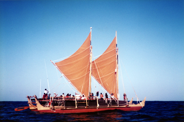
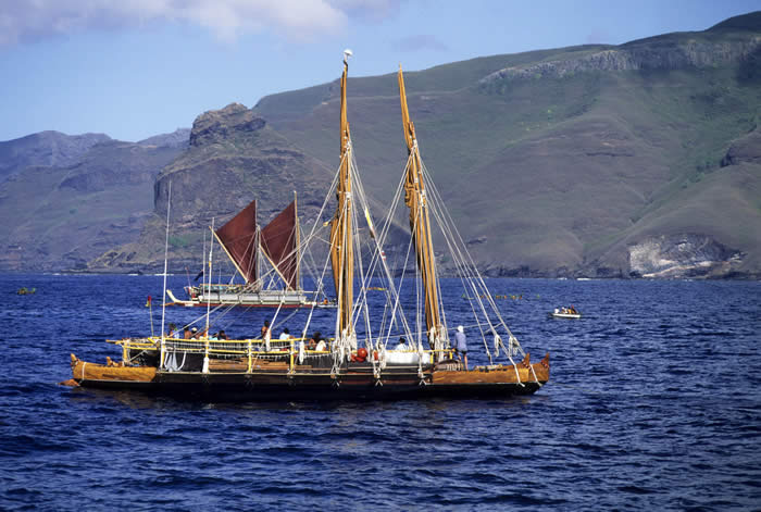
Hokule'a (Hawai'i; 62 ft. [52 ft. at waterline]; double masted)
Navigator/Captain: Chad Baybayan
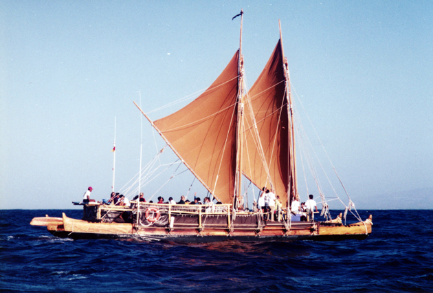
Escort Boat: Gershon II/Steve Kornberg, CaptainHawai'iloa (Hawai'i; 57 ft.; double masted)
Navigator/Captain: Bruce Blankenfeld
Escort Boat: Kama Hele/Alex Jacubenko, CaptainMakali'i (Hawai'i; 54 ft.; single masted)
Navigator: Shorty Bertelmann
Captain: Clay Bertelmann
Escort Boat: Goodewind/Terry Causey, CaptainTe 'Aurere (Aotearoa; 57 ft.; double masted)
Navigators: Jacko Thatcher and Piripi Evans
Captain: Stanley Conrad
Escort Boat: Rizaldar/Randy Wichman, CaptainTe 'Au o Tonga (Rarotonga; 72 ft.; double masted)
Navigators: Tua Pittman (Rarotonga) and Pe'ia Tua'ati (Mauke)
Escort Boat: Three DaughtersTakitumu (Rarotonga; Main hull: 53 ft.; 2nd hull: 49 ft.; single masted)
Navigators: May be navigated with modern equipment.
Escort Boat: Name not known.
The 750 miles sail/tow from Tautira to Taiohae is expected to take about 8 days. (The presents winds will allow the canoes to sail 100-200 miles to the southwest of Nukuhiva, from where they may have to tow in. While the canoes could tack toward the islan d, the schedule of events on Nukuhiva requires the canoes to be in Taiohae by April 12, so towing may be necessary. Estimated day of arrival is April or 12 13.
Over the last two days, the crews have been loading bananas, coconuts, and other fresh fruits from the village of Tautira, and going over safety procedures.
Clyde Aikau, brother of Eddie Aikau, is scheduled to join the crew of Hokule'a in Nukuhiva. Eddie, a lifeguard and surfer, was lost at sea in 1978 when Hokule'a capsized south of Moloka'i. As the disabled canoe was drifting away from the islands, Aikau we nt on his surfboard for help and was never seen again. The incident prompted several changes in modern voyaging practices; for example, the Hawaiian canoes never sail without escort boats today and are equipped with modern communication and tracking devic es.
April 7, 6 a.m., HST
Hawai'iloa, Makali'i, and Te 'Aurere left Tautira on Wednesday, April 5, under tow. There are no winds. Even when the canoes are towing, the navigation by traditional methods continues. The navigator(s) on board the canoe set the direction for the escort boats. Hawai'iloa and Te 'Aurere were being towed by one escort boat: Alex Jacubenko's Kama Hele, which has a huge engine. They are travelling at about 4.5 knots and making about 100 miles a day.
Hokule'a and Te 'Au o Tonga left Tautira on Thursday, April 6. Crew members said they were not sure about the status of the two Tahitian canoes, which did not leave with the rest of the fleet.
April 8
At 7:30 a.m. on April 8, the first group of canoes (Hawai'iloa, Makali'i, Te 'Aurere, Takitumu) were clear of the Tuamotu islands and heading NE toward Nukuhiva, with about 420 miles to go. An ARGOS satellite reading placed them at 13 degrees 30 minutes S , 145 degrees 20 minutes W. They were still under tow. At the current rate of speed, they would make Nukuhiva sometime around Tuesday or Wednesday, April 11 or 12. Hokule'a and Te 'Au o Tonga were just clearing the channel betwen Rangiroa and Arutua in th e Tuamotus (15 degrees 18 minutes S, 146 degrees 58 minutes W), heading NE; they are about 140 miles behind the other canoes. They had found some light winds and were sailing at about 4-5 knots. They should arrive in Nukuhiva one day after the first group .
The two Tahitian canoes (Tahiti Nui and 'A'a Kahiki Nui) were reportedly planning to leave Pape'ete on Friday, April 7. No word as to whether they actually have left or not.
April 9
Hawai'iloa, with Te 'Aurere, Makali'i, and Takitumu, continued on their NE course toward Nukuhiva. At 7 a.m., they were at 12 degrees 22 minutes S; 144 degrees 02 minutes W, about 310 nautical miles from Nukuhiva. Current speed: 3 knots.
Hokule'a, with Te 'Au o Tonga, had cleared the Tuamotus, travelling at 4 knots toward the NE. At 7 a.m., they were at 13 degrees 47 minutes S; 145 degrees 47 minutes W, about 442 nautical miles from Nukuhiva.
Still no news about whether the Tahitian canoes had left Pape'ete.
April 10
At 11 a.m., Hawai'iloa was about 200 miles SE from Nukuhiva at 11 degrees 12 minutes S, 142 degrees 43 minutes W; Hokule'a about 370 miles SE of Nukuhiva at 12 degrees 31 minutes S, 144 degrees 38 minutes W. Estimated arrival for Hawai'iloa: Wednesday, April 12; Estimated arrival for Hokule'a: Thursday, April 13.
Makali'i is no longer carrying a satellite tranponders, so position reports are not available for this canoe. However, the canoe left Tautira a few hours after Hawai'iloa and should be somewhere between Hawai'iloa and Hokule'a.
According to the Honolulu Advertiser, Tahiti Nui left Papeete under tow to Nukuhiva.
April 11
At 7 a.m., Hawai'iloa was 103 miles from Nukuhiva (10 degrees 8 minutes S; 141 degrees 21 minutes W), travelling at 4 knots. It should sight one of the isles of Hiva on the morning of April 12. "Hiva" is the name used in oral traditions to refer to the islands which include Nuku Hiva and Hiva Oa (See Peter Buck, "Vikings of the Sunrise," later retitled "Vikings of the Pacific.") "Marquesas" is a shortened version of "Las Marquesas de Mendoca," a name given to these islands by Alvara Mendana de Neyra, the Spanish explorer who bumped into the southern islands in 1595. (See "Isles of Hiva" for a brief introduction to these islands.)
At 7 a.m., Hokule'a was about 241 miles from Nukuhiva (11 degrees 12 minutes S; 143 degrees, 28 minutes W), travelling at 4 knots. It won't reach the isles of Hiva until Thursday, April 13.
At 11:30 a.m., Ka'au McKenney reported that Hokule'a was under tow. The weather was mild, with 10 knot easterly, northeasterly winds and seas about 3 feet. The fishing has been good: two ahi were caught the day before.
April 12
Hawai'iloa, Te 'Aurere, and Te 'Au o Tonga arrived at Taipi Vai at 9 p.m. last night. This bay 5 miles east of Taiohae on the southern coast of Nukuhiva was made notorious to American and European readers by Herman Melville's 19th century novel "Typee" (i.e., Taipi). The valley was noted for its fierce tatooed warriors. Melville was horrified by the apparently ritualistic practice of cannibalism he discovered there.
Hawai‘iloa and Te ‘Aurere in the Marquesas. Photo by Sam Low
Today Taipa Vai is a small town with a population of one or two hundred people. Subsistence farming and fishing, supplemented by a small tourist trade, are practiced there. The valley is long, deep, and green, the most well-watered in the isles of Hiva . The easterly trade winds bring abundant rainfall, which feeds a large stream that empties into the bay of Taipi Vai. The bay provides relatively safe anchorage.
The dense forests are filled with rock platforms and walls built by the thousands of people who once lived in the valley. Many fell victim to western diseases in the 19th century.
At the back of the valley are some spectacular waterfalls. A dirt/rock road winds and climbs through the valley and over the high mountains at the back, then descends to the beautiful valley of Hatiheu on north coast. A dirt road also connects Taipi Vai with Taiohae, the administrative center of the isles of Hiva and the site for welcoming the visiting fleet of canoes, which will move to Taiohae once all of the canoes have arrived.
At 7 a.m. this morning, Hokule'a was 157 miles from Nukuhiva (10 degrees 1 minutes S; 142 degrees 31 minutes W). Hokule'a, Makali'i, and Takitumu should arrive tomorrow. Tahiti Nui is also in route to Nukukhiva.
April 13
Hokule'a was about 73 miles from Nukuhiva at 7 a.m. this morning. It should arrive sometime this evening. The canoes apparently intend to rendezvous in the bay of Taipi Vai, then sail downwind together along the coast to the bay of Taiohae for welcomin g ceremonies. The U-shaped bay of Taiohae, opening south on the southern coast of Nukuhiva, is the most well protected anchorage in the isles of Hiva, providing shelter except from southerly winds.
April 15
The entire fleet of canoes should be anchored in Taiohae Bay today. Yesterday the canoes that had reached Taiohae by 8 a.m. were welcomed by the residents. At noon, the town observed Good Friday; at 4 p.m. the annual procession from the pier to the Cathedral of Notre Dame took place.
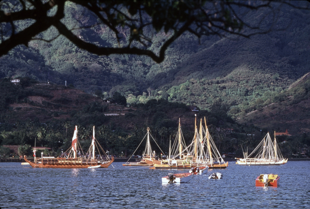
The Voyaging Canoes in Taiohae Bay, Nukuhiva. Photo by Monte Costa
Nukuhiva is the main island of the northern Marquesas Islands. Its population is about 2100. Its surface area is 129 sq. miles, about the size of the island of Lana'i in the Hawaiian islands. Taiohae is its main town, with a small, but modern commercial center (stores, banks, government offices) and four or five small hotels (6-15 rooms).
Schedule for Nukuhiva Events:
April 15, Saturday
7 p.m.: Easter Mass at the Catholic Church (99 % of the population in the Marquesas is Catholic.)
April 16, Sunday
8 a.m.: Religious ceremony at the Cathedral
9 a.m.: Religious ceremony at the Temple
3:30 p.m.: Folkloric Dances performed by delegations and the dance group of Taiohae.April 17, Monday
Sunrise: Preparation of canoes for departure
8 a.m.: Departure ceremony
10 a.m.: Departure of canoes and escort boats for Hawai'i
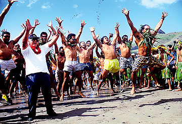
Cook Island voyaging-canoe crew members celebrate after arriving in Taiohae, Nuku Hiva, Marquesas Islands, on April 14, 1995. Photo by Monte Costa
April 18
According to a Honolulu Advertiser report (from correspondent Bob Krauss in Taiohae, Nukuhiva) the latest plan is for the canoe fleet to leave in two groups. Leaving tomorrow, April 19, will be: Hawai'iloa (Hawai'i), Makali'i (Hawai'i), Te 'Aurere (New Z ealand), and Te 'Au o Tonga (Cook Islands)
Hokule'a, which is ready to go, will remain in Taiohae to assist Tahiti Nui (Tahiti) and Takitumu (Cooks Islands) in preparing to sail to Hawai'i. This second group of canoes will leave when all three canoes are ready to go; or if it is determined that any canoe(s) can't go, the other canoe or canoes will go.
At yesterday's ceremonies, Clyde Aikau made a speech in memory of his brother Eddie, a well known surfer and life guard, who was lost at sea when Hokule'a swamped in heavy seas and gale force winds south of the island of Moloka'i in 1978. Aikau said he had been "invited to make the voyage to Hawai'i to complete the cycle of his . . . brother's voyaging."
Also at the ceremonies were a contingent of Kamehameha Schools students who presented a program of traditional song and dance on Sunday, and the hula halau Maui Nui o Kama (a dance trouple from the island of Maui), which chanted "E ala e" for an hour b efore dawn on Monday to bring the sun out of the east over the low eastern mountains of Taiohae bay.
5. Sailing to Hawai'i (Apr. 20-May 2)5
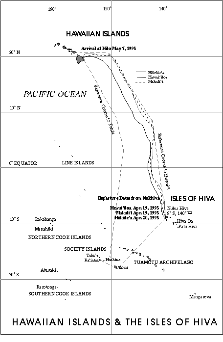
April 20
Afternoon Update: Hokule'a left Taiohae at around 3 p.m. this afternoon.
Hokule'a Crew: Chad Baybayan (Navigator), Moana Doi and Pi'ikea Miller (Asst. Navigators); Snake Ah Hee, Tava Taupu, and Mike Tongg (Watch Captains); Clyde Aikau, Sam Pautu, Mel Paoa (Medical Officer), Mau Piailug, Sesario Sewralur, Gary Suzuki, Nainoa Thompson (Fisherman/Education), Gary Yuen (Cook). The two Cook Island canoes Te 'Au o Tonga and Takitumu left earlier in the day at 10:30 a.m. The Tahitian canoe Tahiti Nui apparently did not leave and will not make the journey north. The morning satellite report placed Hawai'iloa 49 miles north of Nukuh iva at 7 a.m.:
Latitude: 8 degrees 5 minutes S Longitude: 140 degrees, 14 minutes W
The canoe was east of the uninhabited island of Eiao, which in ancient times was a source of basalt used for adzes and of the highly prized red tail feathers of the tropic bird. The island was once inhabited and is occasionally visited by fishermen today.
Hawai'iloa left Nukuhiva yesterday, April 19, at around 6 p.m., with Makali'i and Te 'Aurere.
Hawai'iloa Crew: Bruce Blankenfeld (Navigator), Max Yarawamai (Asst. Navigator); Kainoa Lee (Watch Captain); Kimo Lyman (Watch Captain & Asst. Navigator); Wally Froiseth (Watch Captain); Terry Hee (Fisherman); Archie Kalepa; Ka'au McKenney; Cliff Watson (Documentator / Cameraman); Dr. Nathan Wong (Medical Officer); and Wallace Wong.
Makali'i Crew: Clay Bertelmann (Captain); Shorty Bertelmann (Navigator); Chadd Paishon (Asst. Navigator); Nailima Ahuna, Pomaikai Bertelmann, Kainalu Bertelmann, Nate Hendricks, Kaeo Jones, Kamaka, Robins Kinney, Keahi Omai, Nakoa Prejean, Patty Ann Solom on.
Morning Report: Hokule'a is still in Taiohae, waiting for repairs to be completed on the escort boat for Takitumu. French Polynesian officials are debating whether Tahiti Nui will be able to make the voyage to Hawai'i. The crew has had trouble steering th e canoe because the deck sits so high out of the water; and some have questioned whether the canoe, whose wooden parts are bolted together rather than lashed with cordage, would hold together during a 2,000 miles open ocean voyage.
April 21
Hawai'iloa navigator Bruce Blankenfeld estimated the canoe to be at 5 degrees 50 minutes S, on their reference course, at sunrise. The Reference Course is a local zero degree longitude line against which the navigators plot the distance the canoes travel east or west, using a system of dead reckoning.
The satellite transponder fixed the canoe at 5 degrees 52 minutes S, 140 degrees 31 minutes W, at 7 a.m., or less than ten miles to the east of the navigator's estimate.
The canoe was making 6-8 knots in 15 knot winds under clear skies. Kimo Lyman estimated the canoe to have made 140 miles over the last 24 hours. Makali'i was about 25 miles to the west of Hawai'iloa, with Te 'Aurere just behind.
On nights when the dome of heaven is visible, the navigators of Hawai'iloa and Hokule'a will use celestial bodies for directioncelestial bodies for direction in guiding the canoes. They have memorized the rising and setting points of over a hundred celestial bodies.
The moon is in its last quarter, rising after midnight; the sky has been dark and full of stars used for navigation. Rising at the east horizon before midnight--Na Hiku (the Big Dipper), Hokule'a (Arcturus), Hikianalia (Spica), and Iao (Jupiter) near Mana iakalani (Maui's fishhook, or Scorpio); setting at the western horizon Puana (Procyon).
Yesterday the canoe passed over Ile de Sable (Sand Island), about fifty miles north of Nukuhiva, and to the east of the island of Eiao. Lyman said the crew could see the sandy bottom of the ocean and that Hawai'iloa caught its first fish as it passed over the sandbar.
April 22
Hawai'iloa navigator Bruce Blankenfeld estimated the canoe to be at 3 degrees 2 minutes S on their reference course at sunrise this morning. The canoe made about 168 miles since yesterday at sunrise. Winds were 8-10 knots out of the east, and the canoe wa s making about 4-5 knots. Weather was squally over the last 24 hours (50% cloud cover with showers). Swells from the E and NE.
Kaau McKenney reported that the canoes are trying to stay within 120 miles of each other. They check in on the radio with each other at sunrise and sunset. They are no longer able to see each other.
Satellite Readings:
Hokule'a: 5 degrees 39 minutes S, 141 degrees 12 minutes W
Hawai'iloa: 3 degrees 20 minutes S, 141 degrees 01 minutes W
April 23
No Navigator Reports on Sundays.
Satellite Fixes at 7 a.m.:
Hawai'iloa: 1 degree 27 minutes S; 142 degrees 22 minutes W
Distance from Nukuhiva: 467 nautical miles
Distance to Hilo, Hawai'i: 1480 nm
Current Speed: 5 knots; Current Course: 340 degrees (NNW)Hokule'a: 3 degrees 41 minutes S, 142 degrees 08 minutes W
Distance from Nukuhiva: 336 nautical miles
Distance to Hilo, Hawai'i: 1602 nm
Current speed: 6 knots; Current Course: 329 degrees (NW by N)
April 24
Hawai'iloa's 5th day at sea: Far from any islands now, the only life on the open ocean are lone 'a (boobies) and 'ake'ake (petrels). The canoe crossed the equator yesterday and entered the North Pacific.
Navigator Bruce Blankenfeld estimated Hawai'iloa to be at 1 degree 10 minutes N, 51 miles W of the reference course at 7 a.m.this morning; the canoe made about 120 miles yesterday, an average day of sailing. The winds were slackening--6-8 knots out of the east, and the canoe was travelling at about 4 knots.
Overcast skies and light winds suggest the canoe was approaching the Intertropical Convergence Zone, where doldrum conditions usually prevail.
Sailing up near Hawai'iloa are Makali'i and Te 'Au o Tonga. About 140 miles behind are Hokule'a, with Te 'Aurere. To the east is the Takitumu.
Satellite report at 5:30 p.m.
Hawai'iloa: 2 degrees N; 142 degrees 35 minutes W
Hokule'a: 0 degrees 26 minutes S;143 degrees 13 minutes W
April 25
A rain squall was swirling around Hawai'iloa this morning. Winds were gusting up to 35 miles per hour, so the crew lowered the sails to prevent damage to the rigging. 100 percent cloud cover over the last 12 hours. The conditions are typical of the Intert ropical Convergence Zone, which the canoe has entered, along with Makali'i and Te 'Au o Tonga. These three canoes are staying within 120 miles of each other for safety.
Navigator Blankenfeld estimated Hawai'iloa to be at 2 degrees 54 minutes N, 52 miles west of the reference course at sunrise. Navigator Shorty Bertelmann estimated Makali'i to be at 1 degree 46 minues N, and 40 miles west of the reference course.
At 7 a.m., satellite reports placed Hawai'iloa at 3 degrees 1 minutes N, 142 degrees 17 minutes W (about 10 miles from Blankenfeld's estimate) and Hokule'a at 0 degrees 52 minutes N, 143 degrees 18 minutes W.
At 5:20 p.m. a satellite report placed Hawai'iloa at 3 degrees 40 minutes N, 142 degrees 27 minutes W (the canoe had made about 39 miles to the north during the day). Hokule'a was at 2 degrees 4 minutes N, 143 degrees 5 minutes W (it had gone about 72 mil es north during the day),and will probably cross into the Intertropical Convergence Zone by tomorrow. Hokule'a, Te 'Aurere, and Takitumu are staying within 120 miles of each other for safety.
April 26
A roll call of the six canoes takes place each morning; the navigators' estimated positions were reported over KCCN Radio in Honolulu:
- Hawai'iiloa: 4 degrees 52 minutes N; 5 miles W of the Reference Course (RC)
- Te 'Au o Tonga: 4 degrees 2 minutes N; 60 miles W of the RC
- Makali'i: 3 degrees 43 minutes N; 33 miles W of the RC
- Te 'Aurere: 2 degrees 43 minutes N; 61 miles W of the RC
- Takitumu: 2 degrees 38 minutes N; 18 miles E of the RC
- Hokule'a: 1 degree 57 minutes N; 5 miles E of the RC
Satellite Reports:
Hawai'iloa: 4 degrees 50 miniutes N; 142 degrees 14 minutes W
Hokule'a: 3 degrees 18 minutes N; 142 degrees 52 minutes W
Weather Report from the canoe: Both Hokule'a and Makali'i are reporting 80-100 % cumulus cloud cover. Winds are steady from E by S to ESE at 5-15 knots. Both canoes are heading due north at about 5 knots, and averaging about 5 knots over the last 24 hours . Both canoes made an estimated 120 miles yesterday. The canoes have not been becalmed yet, and are making steady progress through the Intertropical Convergence Zone.
Dominant 3-5 foot swell coming from the NE (generated by the NE tradewinds) and a small swell coming from the SE (generated by the SE tradewinds). Nighttime visibility has been poor, but last night Makali'i was able to steer by the Southern Cross and the Little Dipper; Hokule'a by Na Hiku (the Big Dipper) and Jupiter rising ESE. Navigator Chad Baybayan of Hokule'a used Miaplacidus in the constellation Carina to check his latitude (His hand measurement estimated the star at about 19.5 degrees in altitude a s it crossed the meridian over due south; the star at his latitude was actually closer to 18 degrees in altitude.)
Fishing Report:
Hokule'a landed a 25 lb. aku yesterday and is catching one fish every two days; Makali'i has caught two fish since leaving Nukuhiva on April 19.
Sealife: Hokule'a sighted nai'a (porpoises) two nights ago.
Mau Piailug has been cooking on a traditional stone oven on Hokule'a. A couple of the crew members are eating a traditional diet.
April 27
The canoe fleet ran into full doldrum conditions over the last 24 hours--100 % cloud cover and 0-5 knot winds. After 16 hours of almost no progress (0-1 knot) the canoes decided to allow their escort boats to tow them through the doldrums so they can make it to Hawai'i in time for the planned ceremonies on May 11 and 13.
The navigators are still directing the canoes/escort boats, steering by the sun, the faint waning moon rising and setting near the sun (New Moon tomorrow night), and the swells, which are 4-5 feet from the NE. All the canoes are heading on northerly cours es.
Estimated positions at sunrise:
- Hawai'iloa: 5 degrees, 15 minutes N, 11 miles E of the Reference Course (RC).
- Te 'Au o Tonga: 5 degrees, 15 minutes N, 50 miles W of the RC.
- Makali'i: 5 degrees, 12 minutes N, 23 miles W of the RC.
- Takitumu: 5 degrees 10 minutes N, 6 miles E of the RC.
- Te 'Aurere: 4 degrees 16 minutes N ,51 miles W of the RC.
- Hokule'a: 4 degress 16 minutes N, 1 miles E of the RC.
Satellite reports (Actual Positions at 7:15 a.m.)
Hawai'iloa: 6 degrees 6 minutes N, 142 degrees 5 minutes W, 1131 miles from Hilo
Hokule'a: 4 degrees 46 minutes N, 142 degrees 56 miniutes W, 1152 miles from Hilo
Sea Life: Hokule'a reported seeing a 6-7 foot shark and a few birds.
Mau Piailug, Sesario Sewralur (his son), Tava Taupu, and Mike Tongg on board Hokule'a are eating only traditional foods.
April 28
The canoe fleet found wind again and are undersail. Makali'i reported 10-15 knot winds out of the NE; the canoe was sailing at 5.5 knots.
Last night, with almost total cloud cover, Shorty Bertelmann and Chad Paishon guided Makali'i by the 4-5 foot NE swell and the bright planets Jupiter rising ESE in the early evening and Venus, rising east in the early morning.
By morning, the sky was clear and sunny and the winds had returned.
Estimated positions at sunrise:
- Te 'Au o Tonga: 8 degrees 32 minutes N, 72 miles W of the Reference Course (RC).
- Hawai'iloa: 7 degrees 7 minutes N, 35 miles W of the RC.
- Takitumu: 7 degrees 6 minutes N, 30 miles E of the RC.
- Makali'i: 6 degrees 38 minutes N, 7 miles E of the RC.
- Te 'Aurere: 5 degrees 31 minutes N, 36 miles W of the RC.
- Hokule'a: 5 degrees 30 minutes N, 4 miles W of the RC.
Satellite Reports (Actual Positions at 7 a.m.)
Hawai'iloa: 7 degrees 59 minutes N ,142 degrees 58 minutes W
Hokule'a: 6 degrees 16 minutes N, 143 degrees 42 minutes W
April 29, 1995
Satellite Reports (7 a.m.)
Hawai'iloa: 9 degrees 46 minutes N; 144 degrees 13 minutes W
Hokule'a: 8 degrees 10 minutes N; 144 degrees 41 minutes W
Hawai'iloa has cleared the Intertropical Convergence Zone and entered the third segment of its journey (9 degrees N to 20.5 degrees N). The canoe is pointing toward the Hawaiian islands in a direction called Nalani Ho'olua (NW by N); with the west-flowing North Equatorical current, the true heading is Manu Ho'olua (NW). The canoe is travelling at 5 knots, and made about 130 miles yesterday. It is 874 nautical miles out of Hilo. In the NE tradewind zone, with average 15-25 knot winds the canoe will travel between 100-200 miles per day and should reach Hawai'i in a week.
Hokule'a is 926 nautical miles from Hilo and about 1 sailing day behind Hawai'iloa, travelling at 4 knots. It travelled about 120 miles over the last 24 hours.
As the canoes arrive, each will travel to a different port:
- Hawai'iloa: Hilo, Big Island
- Hokule'a: Hana, Maui (maybe?)-Kalaupapa, Moloka'i
- Makali'i: Kawaihae, Big Island
- Te 'Au o Tonga: Kauanakakai, Moloka'i
- Takitumu: Maui or Lana'i
- Te 'Aurere: Honaunau
The plan is then for the the canoes to gather at Kalaupapa on May 10 and to sail to Kualoa, Oahu on May 11. These plans could change, depending on when the canoes arrive.
Update from Tahiti: An escort boat, "Possible," has left Pape'ete, Tahiti for Taiohae, Nukuhiva, to meet the Tahitian canoe "Tahiti Nui." The canoe and escort boat are planning to leave Nukuhiva for Hawai'i on May 4; estimated arrival: sometime at the end of May.
May 1
Satellite Reports (7 a.m. HST)
Hawai'iloa: 14 degrees 01 minutes N; 146 degrees 27' W
Hokule'a: 12 degrees 22 minutes N; 147 degrees 26 minutes W
The canoes are sailing in the Northeast Tradewinds, which are blowing about 15 knots ENE. The canoes are travelling 6-7 knots, making about 150 miles a day. They are about 600 miles from Hilo and should make landfall by this weekend.
Positions for all the canoes were not reported this morning, as radio communication from canoe to land was difficult. However, all canoes checked in with each other and are in good shape. Hawai'iloa is near the front of the fleet, and Hokule'a toward the back. However, Hokule'a is farther west than Hawai'iloa, and therefore almost as close to Hawai'i as Hawai'iloa is.
May 2, 1995
Nainoa Thompson reported this morning that Te 'Au o Tonga ("The Southern Mist"), the 72-foot double-hulled canoe from the Cook Islands,is a couple of sailing days from Hilo, Hawai'i. Estimated time of arrival (ETA): Wednesday night into Hilo Harbor. The c anoe plans to sail to Kaunakakai, Moloka'i, arriving on Saturday, May 8, for a welcome ceremony.
Thompson also gave the following ETA's and Destinations of the arriving canoes:
- Hawai'iloa: May 5, Friday morning into Hilo
- Makali'i: May 5, Friday morning into Kawaihae
- Takitumu: May 5, Friday night into Ka'anapali or Kahului, Maui, depending on weather.
- Hokule'a: May 6, Saturday into Hilo or Kawaihae; or Ka'anapali or Kahului, depending on weather.
- Te 'Aurere: May 7, Sunday into Kawaihae
A storm front may come through the Hawaiian archipelago on Sunday, so canoes will seek shelter in the closest, safest harbor available.
Navigator's estimated positions (Sunrise)
- Makali'i: 16 degrees 45 minutes N, 116 miles W of the reference course
- Hawai'iloa: 16 degrees 29 minutes N, 153 miles W of the reference course
- Hokule'a: 15 degrees 00 minutes N, 59 miles W of the reference course
The canoes reported winds from NE to ENE at 12-15 knots; swells from the NE at 3-4 feet. Yesterday was squally, but the night was clear, with all the navigation stars visible, as well as the planets--Mercury setting with the crescent moon (Hoaka) at sunse t, and the rising Jupiter and Venus.
Makali'i reported seeing Hawai'iloa on the horizon to the West yesterday.
Satellite reports (7 a.m. HST)
Hawai'iloa: 16 degrees 39 minutes N, 147 degrees 54 minutes W
Hokule'a: 14 degrees 49 minutes N, 148 degree 37 minutes W
Both canoes were travelling at 6-7 knots and were about 450 miles or three sailing days from Hilo.
6. In Hawai'i (May 3-14)
May 3
Nono flies have been reported on three of the six canoes--Hawai'iloa, Makali'i and Te'Aurere. These nearly invisible flies sting; their bites itch, and when the resulting blister is scratched, it become infected and fester. Crew members have reported bite s.
The flies were introduced during the early 20th century to the Marquesas Islands by German trading ships stopping there on their way from New Guinea to Chile. Attempts to eradicate the fly have been unsuccessful.
Plans are being made to prevent the introduction of this fly to Hawai'i. The US Department of Agriculture is providing canisters of an insecticide derived from daisies; the US Coast Guard plans to airlift the canisters to all the canoes and escort boats T hursday morning, so the vessels can be sprayed. All vessels will stay outside a 100-mile boundary around Hawai'i until this spraying can take place. The three uninfested canoes will then proceed onto Hilo, arriving perhaps on Friday. The three infested ca noes will maintain a 24-hour quarantine outside the 100 mile boundary. If no signs of nono flies appear, the canoes will proceed onto Hilo, arriving Saturday.
Positions of the canoes reported by their escort boats or satellite transponders at 8-8:30 a.m.:
- Te 'Au o Tonga: 19 degrees 22 minutes N; 151 degrees 08 minutes W
- Hawai'iloa: 19 degrees 16 minutes N; 149 degrees 20 minutes W
- Makali'i: 19 degrees 12 minutes N; 149 degrees 14 minutes W
- Hokule'a: 17 degrees 19 minutes N; 149 degrees 54 minutes W
- Takitumu: 16 degrees 37 minutes N; 147 degrees 47 minutes W
- Te 'Aurere: 15 degrees 10 minutes N; 148 degrees 46 minutes W
May 4
The US Coast Guard began airdropping canisters of pesticides to the canoes this morning at 8 a.m. The first drop of six cans went to Hokule'a positioned at 18 degrees 35 minutes N;150 degrees 48 minutes W. The plane planned to fly a loop, first SE to Te ' Aurere, the farthest south of the six canoes; then north to Takitumu; then Northwest to Hawai'iloa and Makali'i, positioned together at 20 degrees N, 150 degrees 25 minutes W; then to Te 'Au o Tonga.
May 5
More on the biting fly on board the canoes, from Dr. Paul Martin:
Tahitian govenrment has spent $3 MM so far to try to eradicate the nono, without success. Impact of the flies on the Marquesas has been disastrous.
The flies breed in wet sand; a single fly is capable of inflicting 5000 bites per hour on a person. Their range is 1 km over water under their own power; 20 km if aided by the wind.
Crews have completed spraying of the canoes at sea and have been scrubbing down the canoes, emptying the holds and cleaning equipment, supplies, and personal gear. Sails have been dragged in seawater. All plant and organic materials have been dumped overb oard.
After the initial spraying of insecticide (pyrethrin) 100 miles from land, an inspection team from the Hawai'i department of agriculture will go and meet the canoes 5 miles out at sea, where it will inspect the canoes and spray insecticide over the surfac es again. Fans will be placed in the holds [to reduce the flight potential of the flies? to reduce the humidity in which the flies thrive?] Then the hulls will be sealed.
The canoes will then be escorted into Hilo Harbor, where the crews will disembark without opening the sealed hulls. The canoes will then be sprayed a third time, and the sealed hulls will be fumigated with Vikane for 24 hours. Twelve hours will be needed to aerate the hulls after they are unsealed
Te Au o Tonga entered Hilo Harbor this afternoon and has undergone treatment. Hokule'a, Hawai'iloa, and Makali'i may come in on Saturday or Sunday; Takitumu and Te 'Aurere on Sunday or Monday.
Satellite reports (7 a.m.)
Hawai'iloa: 20 degrees 14 minutes N; 152 degrees 22 minutes W
Hokule'a: 19 degrees 32 minutes N; 152 degrees 22 minutes W
May 7
All five remaining canoes (Hokule'a, Hawai'iloa, Makali'i, Takitumu, and Te 'Aurere) arrived safely in Hilo Harbor this afternoon to join Te 'Au o Tonga, which arrived Friday. No nono flies were detected on board any of the canoes. The weather was rainy, as a front passing over the Hawaiian Archipelago was over the Big Island today. The welcome was subdued, with mainly supporters of Makali'i, which was built on the Big Island, in the crowd. Pua Case Lapulapu and her halau (school) chanted. The Maori did a haka (dance) as they disembarked from their canoe. Chadd Paishon, assistant navigator on board Makali'i, summed up the feelings of the Hawaiians: "We're glad to be home."
May 8
Fumigation of the canoes that arrived Sunday has been completed. The tents placed over the canoes to seal them were removed this morning. After the canoes are aerated for 12 hours, the crews will be allowed back on to prepare for departure.
Te 'Au o Tonga, which arrived last Friday left today for Kaunakakai, on the south coast of Moloka'i, for a welcome ceremony tomorrow, keeping a commitment made by navigators Tua Pittman and Pe'ia Tua'ati to the schoolchildren of Moloka'i to bring the Cook Island canoe to them. Pittman and Tua'ati came to Hawai'i for navigation training with Nainoa Thompson and the Hawaiian navigators last year, and visited Moloka'i on one of the training sails.
The other five canoes plan to leave Hilo tomorrow and arrive on Wednesday at Kalaupapa, on the north shore of Moloka'i. The canoes plan to sail to Kualoa on O'ahu on Thursday morning, May 11, for the dedication of an ahu (altar) to voyaging. The crews wil l be hosted by the people of Hakipu'u. They will be joined by the student crew of the double-hulled canoe E'ala, which has been sailing the coastlines of Hawai'i for the last three months; and by Mo'olele, a double-hulled canoe from the island of Maui.
May 10
High surf advisory for the the north and west shores of all Hawaiian islands caused a change in plans for the canoes. Instead of going to Kalaupapa on the north shore of Moloka'i, the five canoes which left Hilo yesterday are sailing for Kaunakakai on the south shore of Moloka'i, where they will join Te 'Au o Tonga. From Kaunakakai, the canoes will depart late Wednesday night or early Thursday morning for Kualoa in Kane'ohe on the island of O'ahu. Each canoe is carrying a stone from its home island; these stones will be placed on an ahu (altar) dedicated to voyaging at Kualoa. The canoes will start arriving at 9 a.m., and will be anchored offshore by 12 noon. Ceremonies for the crews and their families will be held from 12 - 3 p.m. The canoes will depart for Maunalua Bay on the south shore of O'ahu on Friday morning, then sail into Ke'ehi lagoon on Saturday morning.
Nono Update: Department of Agriculture inspection teams examined the canoes after the fumigation on Sunday and found no dead nono flies among the specimins collected on board, which included ants and flies that are already present in Hawai'i. Nainoa Thomp son, project director, said that the Polynesian Voyaging Society plans to develop guidelines and procedures for preventing the introduction of pests to Hawai'i from any future ports of call.
May 11-13
The Hawaiian canoes are finally home, completing their 6000 miles, 3 month long journey to the South Pacific and back. The canoes returned with mana (power) that only a successful voyage can bring to a canoe. It was Hokule'a's fifth voyage, Hawai'iloa's and Makali'i's first.
On May 11, Thursday, Hokule'a and Hawai'iloa sailed in 20-30 knots easterly tradewinds and 6-8 foot seas across the Kaiwi Channel between Moloka'i and O'ahu into Kane'ohe Bay for a welcoming ceremony by the people of Hakipu'u, the ahupua'a (land division) from whic h Hokule'a was launched twenty years ago in 1975. These two canoes were joined by the 47 foot double-hulled canoe Mo'olele, of Maui, which also sailed the channel.
Representatives of the other canoes which sailed to Hawai'i from Nukuhiva were on board Hokule'a and Hawai'iloa and were also welcomed to Hakupu'u. Te 'Au o Tonga, Takitumu, Te 'Aurere, and Makali'i sailed directly to Honolulu Harbor from Moloka'i instead of coming into Kane'ohe Bay to avoid the risk of being pinned down there by the strong and gusty tradewinds that have been blowing for the last week or so in Hawai'i.
On Friday, Hokule'a and Hawai'iloa sailed/towed around Makapu'u Point and into Honolulu Harbor. The smaller Mo'olele was unable to make the trip due to the strong winds and high seas.
Friday night: Takitumu, which had broken its mast sailing in the strong tradewinds out of Hilo, was re-rigged with a new mast.
May 13, Saturday: 3 a.m. crew call. The six voyaging canoes, joined by the 47-foot double-hulled canoe E'ala, towed out of Honolulu Harbor and went sailing off of Waikiki.
Hokule‘a off Le‘ahi at Sunrise. Photo by Sam Low
Hawai‘iloa off Honolulu
Makali‘i
Eala
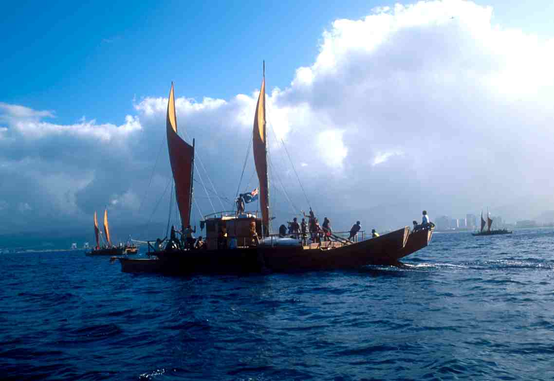
Te ‘Au Tonga off of Honolulu, 1995. Photo by Sam Low
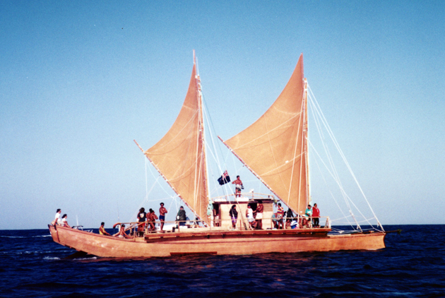
Te ‘Au Tonga
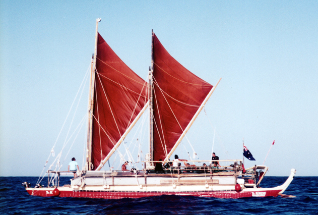
Te ‘Aurere
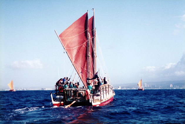
Te ‘Aurere
Takitumu
On this protected leeward side of the island, the winds were lighter, 10-15 knots. The morning was clear and bright, with clouds piled high over the Koolau mountains, which shelter Honolulu Harbor from the tradewinds. Just after sunrise, all seven canoes unfurled their sails and went south, then turned back toward Ke'ehi Lagoon for the public welcome ceremony. It was a magnificent sight to see seven voyaging canoes under sail off Waikiki--perhaps a once in a lifetime event.
At 8:30 a.m., the canoes were towed into Ke'ehi and lined up along the beach. Cook Island, Maori, and Marquesan delegations performed song and dances, along with Hawaiian groups chanting, dancing, and singing. The crews of the various canoes were ceremoniously questioned, then greeted. By 4 p.m., the canoes were tied up safely at Pier 36, where Hawai'iloa was completed and launched.
Voyaging canoes sailing in Mamala Bay off Honolulu, 1995
Welcome celebration at Ke‘ehi
May 14, Sunday Morning: 7 a.m.
Hokule'a and Hawai'iloa were towed across Honolulu Harbor by tugboat, to be loaded onto a Matson container ship which would depart for Seattle on Monday. The two canoes will be unloaded in Seattle and will visit various sites in the Puget Sounds Area, and up to Vancouver, BC, before splitting up; Hawai'iloa will travel north to Juneau, Hokule'a south to Portland, SF, Long Beach, and San Diego this summer.